ფაილი:West Bank Access Restrictions June 2020.pdf

თავდაპირველი ფაილი ((4 964 × 7 020 პიქსელი, ფაილის ზომა: 15,18 მბ, MIME ტიპი: application/pdf))
| ეს ფაილი მდებარეობს Wikimedia Commons სერვერზე. იხილეთ მისი აღწერის გვერდი სრული ინფორმაციისთვის. |
 |
გადასვლა ფაილის გვერდზე |
რეზიუმე
| აღწერა |
English: West Bank access restrictions map |
| თარიღი | |
| წყარო | https://www.ochaopt.org/sites/default/files/westbank_a0_25_06_2020_final.pdf |
| ავტორი | United Nations OCHA oPt |
ლიცენზია
| This image is a map derived from a United Nations map.
Unless stated otherwise, UN maps are to be considered in the public domain. This applies worldwide. UN maps are, in principle, open source material and you can use them in your work or for making your own map. UN requests however that you delete the UN name, logo and reference number upon any modification to the map. Content of your map will be your responsibility. You can state in your publication, if you wish, something like: based on UN map … (map name, map number, revision number and date). See: Geospatial Information Section. And: Geospatial, location data for a better world. |
 |
ფაილის ისტორია
დააწკაპუნეთ თარიღზე/დროზე ფაილის დასათვალიერებლად, როგორც ის მაშინ გამოიყურებოდა.
| თარიღი/დრო | მინიატიურა | ზომები | მომხმარებელი | შენიშვნა | |
|---|---|---|---|---|---|
| მიმდინარე | 13:53, 20 მაისი 2021 | 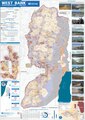 | 4 964×7 020 (15,18 მბ) | Jul059 | Lossless file size reduction |
| 20:33, 14 დეკემბერი 2020 | არ არის მინიატურა | 0×0 (15,92 მბ) | Veggies | Updated for 2020 | |
| 17:32, 27 იანვარი 2016 | არ არის მინიატურა | 0×0 (17,08 მბ) | Triggerhippie4 | User created page with UploadWizard |
ბმულები
ამ ფაილზე ბმული მოცემულია შემდეგ გვერდებზე:
ფაილის გლობალური გამოყენება
ეს ფაილი გამოიყენება შემდეგ ვიკებში:
- გამოყენება ar.wikipedia.org-ში
- გამოყენება arz.wikipedia.org-ში
- გამოყენება azb.wikipedia.org-ში
- გამოყენება cs.wikipedia.org-ში
- გამოყენება de.wikipedia.org-ში
- გამოყენება de.wikivoyage.org-ში
- გამოყენება el.wikipedia.org-ში
- გამოყენება en.wikipedia.org-ში
- Israeli settlement
- West Bank
- Population statistics for Israeli settlements in the West Bank
- Israeli checkpoint
- Settler colonialism
- Area C (West Bank)
- User:Falcaorib
- Palestinian enclaves
- Zionism as settler colonialism
- User:Carter McCrae/Israeli–Palestinian conflict
- Israeli incursions in the West Bank during the Israel–Hamas war
- გამოყენება en.wikivoyage.org-ში
- გამოყენება eo.wikipedia.org-ში
- გამოყენება eu.wikipedia.org-ში
- გამოყენება fa.wikipedia.org-ში
- გამოყენება fr.wikipedia.org-ში
- გამოყენება fy.wikipedia.org-ში
- გამოყენება ha.wikipedia.org-ში
- გამოყენება he.wikipedia.org-ში
- გამოყენება he.wikiquote.org-ში
- გამოყენება id.wikipedia.org-ში
- გამოყენება it.wikivoyage.org-ში
- გამოყენება ja.wikipedia.org-ში
- გამოყენება ko.wikipedia.org-ში
- გამოყენება nl.wikipedia.org-ში
- გამოყენება nl.wikinews.org-ში
- გამოყენება pcm.wikipedia.org-ში
- გამოყენება pl.wikipedia.org-ში
- გამოყენება pt.wikipedia.org-ში
- გამოყენება ru.wikipedia.org-ში
იხილეთ, ამ ფაილის გლობალური გამოყენება.