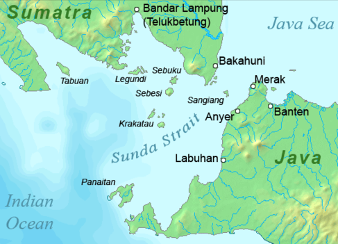
Sunda_strait_map_v4.png ((487 × 351 პიქსელი, ფაილის ზომა: 176 კბ, MIME ტიპი: image/png))

ეს ფაილი მდებარეობს Wikimedia Commons სერვერზე.
იხილეთ მისი აღწერის გვერდი სრული ინფორმაციისთვის.
გადასვლა ფაილის გვერდზე

რეზიუმე

აღწერა
Deutsch: Karte der Sundastraße, Indonesien
English: Map of the Sunda Strait, Indonesia
თარიღი
წყარო პირადი ნამუშევარი
ავტორი Telim tor
უფლება
(ფაილის მეორეული გამოყენება)
Public domain
This image is in the public domain because it came from the site https://www.demis.nl/products/web-map-server/examples/ and was released by the copyright holder. Permission is granted to copy, distribute and/or modify this map since it is based on free of copyright images from: www.demis.nl. See also approval email on de.wp and its clarification.

Deutsch | English | македонски | മലയാളം | Nederlands | slovenščina | +/−

Public domain This work has been released into the public domain by its copyright holder, www.demis.nl. This applies worldwide.
ზოგიერთ ქვეყანაში ეს შეიძლება იურიდიულად შეუძლებელი იყოს, ასეთ შემთხვევაში:
www.demis.nl უფლება მისცა ნებისმიერს, რათა გამოიყენონ ეს ნამუშევარი ნებისმიერი მიზნით, ყოველგვარი წინაპირობის გარეშე, თუ რაიმე პირობა კანონის მიერ არ არის მოთხოვნილი.

სხვა ვერსიები
image extraction process
This file has been extracted from another file
: Sunda strait map v3.png
original file

Captions

Add a one-line explanation of what this file represents

source of file ინგლისური

original creation by uploader ინგლისური

ფაილის ისტორია

დააწკაპუნეთ თარიღზე/დროზე ფაილის დასათვალიერებლად, როგორც ის მაშინ გამოიყურებოდა.

თარიღი/დრომინიატიურაზომებიმომხმარებელიშენიშვნა
მიმდინარე11:37, 23 იანვარი 2011მინიატურა 11:37, 23 იანვარი 2011 ვერსიისთვის487×351 (176 კბ)Telim tor== {{int:filedesc}} == {{Information |Description={{en|Map of the Sunda Strait, Indonesia}} |Source={{own}} |Date=2011-01-23 |Author=Telim tor |Permission={{PD-Demis}} |other_versions=={{Extracted from|Sunda_strait_map_v3.png}} }} [[Ca

ამ ფაილზე ბმული მოცემულია შემდეგ გვერდებზე:

ფაილის გლობალური გამოყენება

ეს ფაილი გამოიყენება შემდეგ ვიკებში:

მოძიებულია „https://ka.wikipedia.org/wiki/ფაილი:Sunda_strait_map_v4.png“-დან