ფაილი:ISS-30 Lake Fitri, Chad.jpg
ზომა წინასწარი გადახედვისას: 800 × 531 პიქსელი. სხვა გაფართოება: 320 × 213 პიქსელი | 640 × 425 პიქსელი | 1 024 × 680 პიქსელი | 1 280 × 850 პიქსელი | 2 560 × 1 700 პიქსელი | 4 288 × 2 848 პიქსელი.
თავდაპირველი ფაილი ((4 288 × 2 848 პიქსელი, ფაილის ზომა: 6,37 მბ, MIME ტიპი: image/jpeg))
| ეს ფაილი მდებარეობს Wikimedia Commons სერვერზე. იხილეთ მისი აღწერის გვერდი სრული ინფორმაციისთვის. |
 |
გადასვლა ფაილის გვერდზე |
რეზიუმე
| აღწერა |
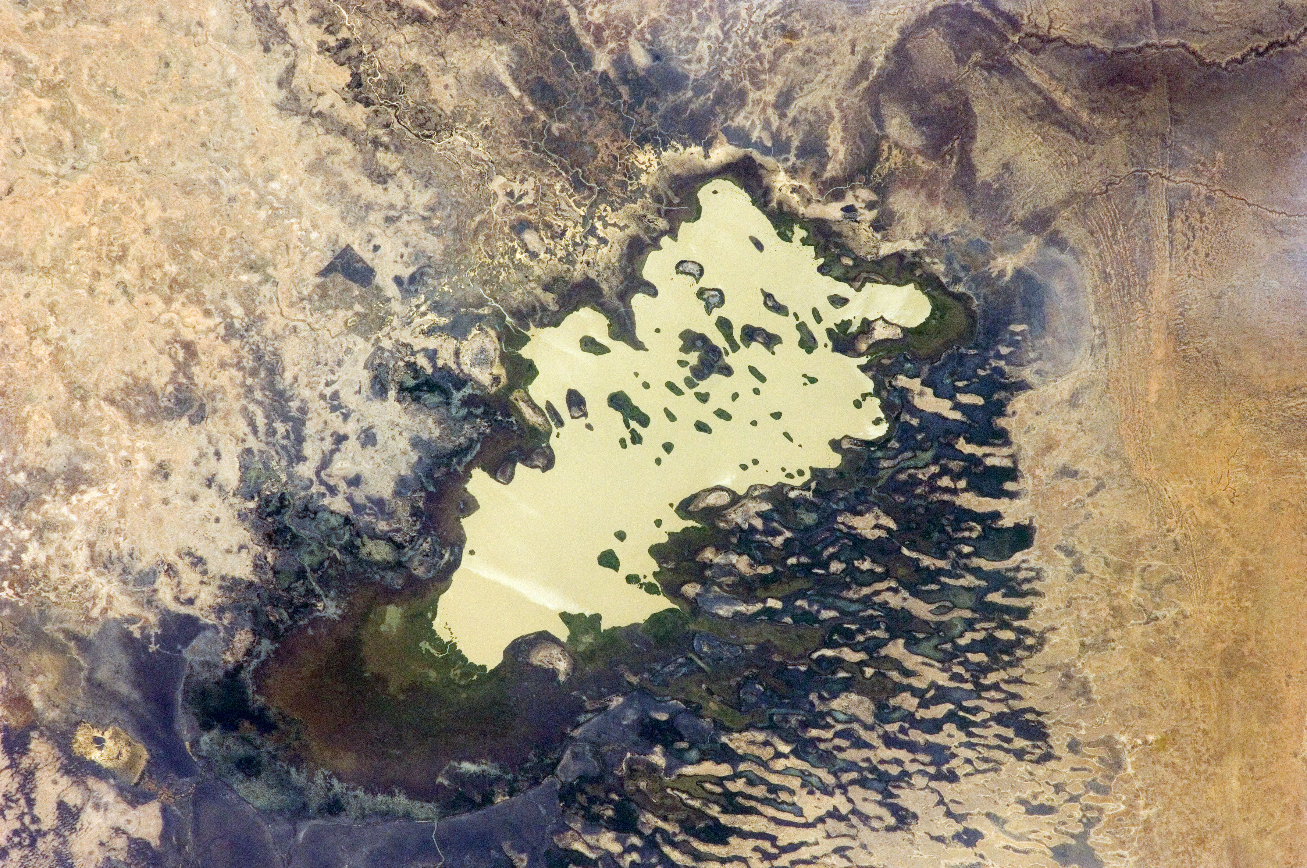
English: Lake Fitri, Chad is featured in this image photographed by an Expedition 30 crew member on the International Space Station.
|
| თარიღი | |
| წყარო | http://spaceflight.nasa.gov/gallery/images/station/crew-30/html/iss030e059398.html |
| ავტორი | NASA |
This image or video was catalogued by Johnson Space Center of the United States National Aeronautics and Space Administration (NASA) under Photo ID: ISS030-E-059398. This tag does not indicate the copyright status of the attached work. A normal copyright tag is still required. See Commons:Licensing. Other languages:
|
ლიცენზია
This file is in the public domain in the United States because it was created by the Image Science & Analysis Laboratory, of the NASA Johnson Space Center. NASA copyright policy states that "NASA material is not protected by copyright unless noted". (NASA media use guidelines or Conditions of Use of Astronaut Photographs).
Photo source: ISS030-E-59398.
|
ფაილის ისტორია
დააწკაპუნეთ თარიღზე/დროზე ფაილის დასათვალიერებლად, როგორც ის მაშინ გამოიყურებოდა.
| თარიღი/დრო | მინიატიურა | ზომები | მომხმარებელი | შენიშვნა | |
|---|---|---|---|---|---|
| მიმდინარე | 20:00, 20 აპრილი 2016 | | 4 288×2 848 (6,37 მბ) | Ras67 | new rendered in high quality from NASA's raw image data |
| 12:46, 4 ივნისი 2012 |  | 4 288×2 848 (2,03 მბ) | Ras67 | levels | |
| 17:59, 21 თებერვალი 2012 |  | 4 288×2 848 (1,76 მბ) | Ras67 | {{Information |Description ={{en|1=Lake Fitri, Chad is featured in this image photographed by an Expedition 30 crew member on the International Space Station. Lake Fitri is an endorheic, or terminal lake in a desert basin in the southern Sahara Desert. |
ბმულები
ამ ფაილზე ბმული მოცემულია შემდეგ გვერდებზე:
ფაილის გლობალური გამოყენება
ეს ფაილი გამოიყენება შემდეგ ვიკებში:
- გამოყენება ar.wikipedia.org-ში
- გამოყენება arz.wikipedia.org-ში
- გამოყენება be.wikipedia.org-ში
- გამოყენება cv.wikipedia.org-ში
- გამოყენება de.wikipedia.org-ში
- გამოყენება el.wikipedia.org-ში
- გამოყენება en.wikipedia.org-ში
- გამოყენება es.wikipedia.org-ში
- გამოყენება fr.wikipedia.org-ში
- გამოყენება id.wikipedia.org-ში
- გამოყენება it.wikipedia.org-ში
- გამოყენება lt.wikipedia.org-ში
- გამოყენება my.wikipedia.org-ში
- გამოყენება nl.wikipedia.org-ში
- გამოყენება pl.wikipedia.org-ში
- გამოყენება ru.wikipedia.org-ში
- გამოყენება vi.wikipedia.org-ში
- გამოყენება www.wikidata.org-ში