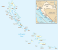
ფაილი:Croatian islands map.png

ზომა წინასწარი გადახედვისას: 669 × 600 პიქსელი. სხვა გაფართოება: 268 × 240 პიქსელი | 535 × 480 პიქსელი | 696 × 624 პიქსელი.
თავდაპირველი ფაილი ((696 × 624 პიქსელი, ფაილის ზომა: 60 კბ, MIME ტიპი: image/png))
ფაილის ისტორია
დააწკაპუნეთ თარიღზე/დროზე ფაილის დასათვალიერებლად, როგორც ის მაშინ გამოიყურებოდა.
| თარიღი/დრო | მინიატიურა | ზომები | მომხმარებელი | შენიშვნა | |
|---|---|---|---|---|---|
| მიმდინარე | 10:51, 6 მარტი 2023 |  | 696×624 (60 კბ) | Nihil scimus | Paklinski + Jelenski otoci |
| 19:56, 5 მარტი 2023 |  | 696×600 (58 კბ) | Nihil scimus | Contrast, Palagruza Is., continents added. | |
| 19:39, 1 მარტი 2006 |  | 696×600 (49 კბ) | Jelte | Map of the w:Croatian w:islands Adapted from http://www.un.org/Depts/Cartographic/map/profile/croatia.pdf and Image:Hr-map.png {{PD-because|Mapping derived from products of the [http://www.un.org/Depts/Cartographic/english/htmain.htm Unite |
ბმულები
ამ ფაილზე ბმული მოცემულია შემდეგ გვერდებზე:
ფაილის გლობალური გამოყენება
ეს ფაილი გამოიყენება შემდეგ ვიკებში:
- გამოყენება ar.wikipedia.org-ში
- გამოყენება avk.wikipedia.org-ში
- Molat (ewala)
- Teza:XrvatskaEwala
- Ist (ewala)
- Škarda (ewala)
- Kamenjak (ewala)
- Maslinjak (ewala)
- Vodenjak (ewala)
- Benušić (ewala)
- Črnikovac (ewala)
- Dužac (ewala)
- Sestrice (ewala)
- Križica (ewala)
- Tramerka (ewala)
- Tramerčica (ewala)
- Obljak (ewala)
- Knežačić (ewala)
- Tovarnjak (ewala)
- Mladinj (ewala)
- Rižnjak (ewala)
- Lušnjak-Kamenjak (ewala)
- Brgulje Otočić (ewala)
- Premuda (ewala)
- Hripa (ewala)
- Bračići (ewala)
- Masarine (ewala)
- Plitka Sika (ewala)
- Lutrošnjak (ewala)
- Kamenjak (ewala poke Premuda)
- Silba (ewala)
- Olib (ewala)
- Morovnik (ewala)
- Šip (ewala)
- Kurjak (ewala)
- Maun (ewala)
- Škrda (ewala)
- Veli Brušnjak (ewala)
- Mali Brušnjak (ewala)
- Lukar (ewala)
- Pohlib (ewala)
- Kornat (ewalatum)
- Kornat (ewala)
- Svršata Vela (ewala)
- Svršata Mala (ewala)
- Buč Veli (ewala)
- Buč Mali (ewala)
- Krpeljina (ewala)
- Bisaga (ewala poke Kornat)
- Ravna Sika (ewala poke Kornat)
- Strižnjak (ewala)
იხილეთ, ამ ფაილის გლობალური გამოყენება.


