ფაილი:Antarctica Without Ice Sheet.png

თავდაპირველი ფაილი ((782 × 1 000 პიქსელი, ფაილის ზომა: 675 კბ, MIME ტიპი: image/png))
| ეს ფაილი მდებარეობს Wikimedia Commons სერვერზე. იხილეთ მისი აღწერის გვერდი სრული ინფორმაციისთვის. |
 |
გადასვლა ფაილის გვერდზე |
რეზიუმე
| აღწერა |
Русский: Рельеф Антарктиды с учетом поднятия земной коры после таяния ледников и повышения уровня океана
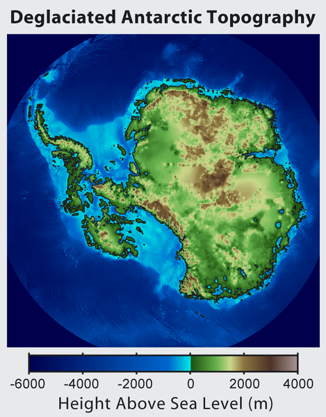
English: This is topographic map of Antarctica after removing the ice sheet and accounting for both isostatic rebound and sea level rise. Hence this map suggests what Antarctica may have looked like 35 million years ago, when the Earth was warm enough to prevent the formation of large-scale ice sheets in Antarctica.
Isostatic rebound is the result of the weight of the ice sheet depressing the land under it. After the ice is removed, the land will rise over a period of thousands of years by an amount approximately 1/3 as high as the ice sheet that was removed (because rock is 3 times as dense as ice). Approximately half the uplift occurs during the first two thousand years. If the ice sheet is removed over more than a few thousand years, then it is possible that a majority of the uplift will occur before the ice sheet fully disappears. As indicated in the map, Antarctica consists of a large continental region (East Antarctica) and group of seas and smaller land regions (West Antarctica). Since the West Antarctic ice sheet is partially anchored below sea level, this region is less stable and more likely to be affected by global warming. Even so, it is likely that during the next century increased precipitation over Antarctica will offset melting. Even in the event of severe sustained warming, it would take many thousands of years for Eastern Antarctica to be fully deglaciated.Français : Carte topographique de l'Antarctique après avoir retirer la couche de glace et pris en compte le rebond isostatique ainsi que la montée du niveau de la mer Par conséquent cette carte montre ce à quoi l'Antarctique aurait pu ressembler il y a 35 millions d'années, quand la Terre était suffisament chause pour prévenir la formation d'une importante calotte glaciaire en Antarctique.
Le rebond isostatique est la conséquence de la couche de glace qui fait pression sur le sol et crée des dépressions. Après le retrait de la glace, le sol s'élève sur une période de milliers d'années par un rythme correspondant à un tiers de la hauteur de la couche de glace qui fut retirée (car la roche est trois fois plus dense que la glace). La moitié de l'élévation se fait pendant les deux premiers milliers d'années. Si la glace se retire sur une période dépassant plusieurs milliers d'année, il est possible que le rebond ait lieu avant que la couche de glace ne disparaisse complètement. Comme montré sur la carte, l'Antarctique est composé d'une large région continentale (Antarctique oriental) et d'un groupe de mers et de petites régions terrestres (Antarctique occidental). Puisque la plaque glaciaire de l'Arctique occidental est en partie en dessous du niveau de la mer, cette région est moins stable et plus susceptible d'être affectée par le réchauffement climatique. En dépit de cela, des précipitation en Antarctique peuvent compenser la fonte. La fonte de l'Antarctique oriental prendra plusieurs milliers d'années, même en cas de réchauffement sévère et continu. |
| თარიღი | |
| წყარო | http://www.globalwarmingart.com/wiki/File:Antarctica_Without_Ice_Sheet_png |
| ავტორი | Image created by Robert A. Rohde / Global Warming Art |
| სხვა ვერსიები | File:Deglaciated Antarctic Topography.png – with no description (internationalized) |
ლიცენზია

|
თქვენ შეგიძიათ გაავრცელოთ ან შეცვალოთ დოკუმენტი GNU Free Documentation ლიცენზიის 1.2 ან უფრო გვიანდელი ვერსიის პირობების თანახმად, რომელიც გამოქვეყნებულია თავისუფალი პროგრამული უზრუნველყოფის ფონდის მიერ, შეუცვლელი განყოფილებების გარეშე, პირველ და ბოლო გვერდებზე განთავსებულ ტექსტებზე. ლიცენზიის ასლი არის განთავსებული განყოფილებაში სახელად GNU Free Documentation License. |
- თქვენ თავისუფლად შეგიძლიათ:
- ნამუშევრის გაზიარება – ნამუშევრის კოპირება, გავრცელება და გადაცემა.
- შექმნათ დაფუძნებულები – ნამუშევრის შესწორება
- შემდეგი პირობებით:
- მოხსენიება – თქვენ უნდა მიუთითოთ წყაროს შემქმნელი იმ გზით, რომელიც დანიშნა ავტორმა ან საავტორო უფლებების მფლობელმა. მაგრამ არა ისე, თითქოს წყაროს ავტორი მხარს გიჭერთ თქვენ ან დაუჭირა თქვენს მიერ შექმნილ ნაწარმოებს.
- გავრცელება იგივე პირობებეით – თუ თქვენ ცვლით, ან ქმნით ახალ ნაშრომს ამ ნამუშევრის გამოყენებთ, თქვენ გაქვთ უფლება გაავრცელოთ იგი იგივე ან შესაბამისი ლიცენზიით, რომლითაც ვრცელდება წყარო.
ფაილის ისტორია
დააწკაპუნეთ თარიღზე/დროზე ფაილის დასათვალიერებლად, როგორც ის მაშინ გამოიყურებოდა.
| თარიღი/დრო | მინიატიურა | ზომები | მომხმარებელი | შენიშვნა | |
|---|---|---|---|---|---|
| მიმდინარე | 16:56, 16 ივნისი 2015 | | 782×1 000 (675 კბ) | Szczureq | larger image |
| 05:57, 10 ოქტომბერი 2012 |  | 469×600 (316 კბ) | Strannik27 | User created page with UploadWizard |
ბმულები
ამ ფაილზე ბმული მოცემულია შემდეგ გვერდებზე:
ფაილის გლობალური გამოყენება
ეს ფაილი გამოიყენება შემდეგ ვიკებში:
- გამოყენება ar.wikipedia.org-ში
- გამოყენება ast.wikipedia.org-ში
- გამოყენება ban.wikipedia.org-ში
- გამოყენება ba.wikipedia.org-ში
- გამოყენება be-tarask.wikipedia.org-ში
- გამოყენება be.wikipedia.org-ში
- გამოყენება br.wikipedia.org-ში
- გამოყენება bxr.wikipedia.org-ში
- გამოყენება ca.wikipedia.org-ში
- გამოყენება cs.wikipedia.org-ში
- გამოყენება de.wikipedia.org-ში
- გამოყენება en.wikipedia.org-ში
- გამოყენება es.wikipedia.org-ში
- გამოყენება es.wikibooks.org-ში
- გამოყენება fr.wikipedia.org-ში
- გამოყენება id.wikipedia.org-ში
- გამოყენება it.wikipedia.org-ში
- გამოყენება ja.wikipedia.org-ში
- გამოყენება kn.wikipedia.org-ში
- გამოყენება la.wikipedia.org-ში
- გამოყენება mn.wikipedia.org-ში
- გამოყენება nl.wikipedia.org-ში
- გამოყენება no.wikipedia.org-ში
- გამოყენება pl.wikipedia.org-ში
- გამოყენება ru.wikipedia.org-ში
- გამოყენება tg.wikipedia.org-ში
- გამოყენება tr.wikipedia.org-ში
- გამოყენება uk.wikipedia.org-ში
- გამოყენება zh.wikipedia.org-ში
- გამოყენება zu.wikipedia.org-ში