ფაილი:1827 Finley Map of Turkey in Europe, Greece and the Balkans - Geographicus - TurkeyEurope-finley-1827.jpg

ზომა წინასწარი გადახედვისას: 467 × 599 პიქსელი. სხვა გაფართოება: 187 × 240 პიქსელი | 374 × 480 პიქსელი | 599 × 768 პიქსელი | 798 × 1 024 პიქსელი | 2 339 × 3 000 პიქსელი.
თავდაპირველი ფაილი ((2 339 × 3 000 პიქსელი, ფაილის ზომა: 1,94 მბ, MIME ტიპი: image/jpeg))
| ეს ფაილი მდებარეობს Wikimedia Commons სერვერზე. იხილეთ მისი აღწერის გვერდი სრული ინფორმაციისთვის. |
 |
გადასვლა ფაილის გვერდზე |
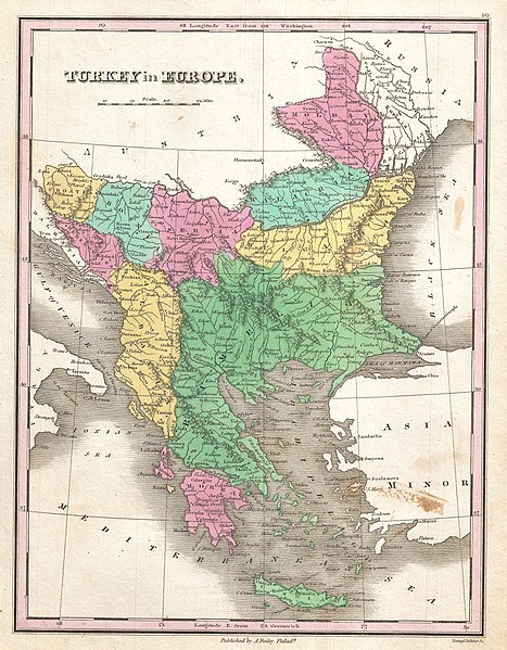
| Anthony Finley: Turkey in Europe.
( |
||||||||||||||
|---|---|---|---|---|---|---|---|---|---|---|---|---|---|---|
| შემსრულებელი |
|
|||||||||||||
| სათაური |
Turkey in Europe. |
|||||||||||||
| აღწერა |
English: A beautiful example of Finley's rare 1827 map of Turkey in Europe. Covers the European lands claimed by the Ottoman Empire in the early 19th century. This includes the modern day nations of Turkey, Greece, Macedonia, Albania, Croatia, Bosnia, Serbia, Montenegro, Bulgaria, Romania and Moldova. In Finley's classic minimalist style, this map identifies cities, forests, river systems, swamps and mountains. Color coded according to regional political boundaries. Title and scale in upper left quadrant. Engraved by Young and Delleker for the 1827 edition of Anthony Finley's General Atlas . |
|||||||||||||
| თარიღი | 1827 (undated) | |||||||||||||
| ზომები | სიმაღლე: 11,5 in (29,2 cm); სიგანე: 9 in (22,8 cm) | |||||||||||||
| საინვენტარო ნომერი |
Geographicus link: TurkeyEurope-finley-1827 |
|||||||||||||
| წყარო/ფოტოგრაფი |
Finley, Anthony, A New General Altas, Comprising a Complete Set of Maps, representing the Grand Divisions of the Globe, Together with the several Empires, Kingdoms and States in the World; Compiled from the Best Authorities, and corrected by the Most Recent Discoveries, Philadelphia, 1827.
|
|||||||||||||
| უფლება (ფაილის მეორეული გამოყენება) |
|
|||||||||||||
| Annotations | This image is annotated: View the annotations at Commons |
ფაილის ისტორია
დააწკაპუნეთ თარიღზე/დროზე ფაილის დასათვალიერებლად, როგორც ის მაშინ გამოიყურებოდა.
| თარიღი/დრო | მინიატიურა | ზომები | მომხმარებელი | შენიშვნა | |
|---|---|---|---|---|---|
| მიმდინარე | 15:35, 16 ნოემბერი 2022 | | 2 339×3 000 (1,94 მბ) | Gyalu22 | Reverted overwriting of artwork |
| 18:45, 8 იანვარი 2020 |  | 2 339×3 000 (4,01 მბ) | Julieta39 | Cleaning freckles, contrast. | |
| 10:10, 23 მარტი 2011 |  | 2 339×3 000 (1,94 მბ) | BotMultichillT | {{subst:User:Multichill/Geographicus |link=http://www.geographicus.com/P/AntiqueMap/TurkeyEurope-finley-1827 |product_name=1827 Finley Map of Turkey in Europe, Greece and the Balkans |map_title=Turkey in Europe. |description=A beautiful example of Finley' |
ბმულები
ამ ფაილზე ბმული მოცემულია შემდეგ გვერდებზე:
ფაილის გლობალური გამოყენება
ეს ფაილი გამოიყენება შემდეგ ვიკებში:
- გამოყენება de.wikipedia.org-ში
- გამოყენება en.wikipedia.org-ში
- გამოყენება fr.wikipedia.org-ში
- გამოყენება hr.wikipedia.org-ში
- გამოყენება it.wikipedia.org-ში
- გამოყენება ro.wikipedia.org-ში
- გამოყენება sh.wikipedia.org-ში
- გამოყენება sq.wikipedia.org-ში
- გამოყენება tl.wikipedia.org-ში
- გამოყენება tr.wikipedia.org-ში