თავდაპირველი ფაილი((1 016 × 1 222 პიქსელი, ფაილის ზომა: 101 კბ, MIME ტიპი: image/jpeg))

ეს ფაილი მდებარეობს Wikimedia Commons სერვერზე.
იხილეთ მისი აღწერის გვერდი სრული ინფორმაციისთვის.
გადასვლა ფაილის გვერდზე
Warning sign This file requires updating because: The earlier forms of this map did not extend a dotted-line around Dongyin, Lienchiang (Tungyin). The northern edge of this map ought to be moved up a little bit (in latitude) so that a dotted line encompassing Dongyin (Tungyin) can be clearly drawn and so that we can see a few of the islands north of Lienchiang County in Haidao Township, PRC. Example of a better map from The Economist: [1]. In doing so, you could add a timestamp to the file.
Please notify the uploader with {{subst:update-note|1=File:Taiwan relief location map.jpg|2=The earlier forms of this map did not extend a dotted-line around Dongyin, Lienchiang (Tungyin). The northern edge of this map ought to be moved up a little bit (in latitude) so that a dotted line encompassing Dongyin (Tungyin) can be clearly drawn and so that we can see a few of the islands north of Lienchiang County in Haidao Township, PRC. Example of a better map from The Economist: [2].}} ~~~~

რეზიუმე

აღწერა
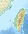
English: Relief location map of Taiwan.
  • Projection: Equirectangular projection, strechted by 110.0%.
  • Geographic limits of the map:
  • N: 26.4° N
  • S: 21.7° N
  • W: 118.0° E
  • E: 122.3° E
  • GMT projection: -JX17.204266666666665cd/20.68512992248063cd
  • GMT region: -R118.0/21.7/122.3/26.4r
  • GMT region for grdcut: -R118.0/21.7/122.3/26.4r
  • Relief: SRTM30plus.
  • Made with Natural Earth. Free vector and raster map data @ naturalearthdata.com.
თარიღი
წყარო პირადი ნამუშევარი
ავტორი Uwe Dedering

ლიცენზია

მე, ამ ნაწარმოებზე საავტორო უფლებების მფლობელი, საკუთარი სურვილით ვაქვეყნებ მას შემდეგი ლიცენზიით:
w:ka:Creative Commons
მოხსენიება გავრცელება იგივე პირობებეით
ეს ნამუშევარი ვრცელდება Creative Commons Attribution-Share Alike 3.0 Unported, 2.5 Generic, 2.0 Generic და 1.0 Generic ლიცენზიით.
თქვენ თავისუფლად შეგიძლიათ:
  • ნამუშევრის გაზიარება – ნამუშევრის კოპირება, გავრცელება და გადაცემა.
  • შექმნათ დაფუძნებულები – ნამუშევრის შესწორება
შემდეგი პირობებით:
  • მოხსენიება – თქვენ უნდა მიუთითოთ წყაროს შემქმნელი იმ გზით, რომელიც დანიშნა ავტორმა ან საავტორო უფლებების მფლობელმა. მაგრამ არა ისე, თითქოს წყაროს ავტორი მხარს გიჭერთ თქვენ ან დაუჭირა თქვენს მიერ შექმნილ ნაწარმოებს.
  • გავრცელება იგივე პირობებეით – თუ თქვენ ცვლით, ან ქმნით ახალ ნაშრომს ამ ნამუშევრის გამოყენებთ, თქვენ გაქვთ უფლება გაავრცელოთ იგი იგივე ან შესაბამისი ლიცენზიით, რომლითაც ვრცელდება წყარო.
GNU head თქვენ შეგიძიათ გაავრცელოთ ან შეცვალოთ დოკუმენტი GNU Free Documentation ლიცენზიის 1.2 ან უფრო გვიანდელი ვერსიის პირობების თანახმად, რომელიც გამოქვეყნებულია თავისუფალი პროგრამული უზრუნველყოფის ფონდის მიერ, შეუცვლელი განყოფილებების გარეშე, პირველ და ბოლო გვერდებზე განთავსებულ ტექსტებზე. ლიცენზიის ასლი არის განთავსებული განყოფილებაში სახელად GNU Free Documentation License.
თქვენ შეგიძლიათ აირჩიოთ ლიცენზია.

Captions

Add a one-line explanation of what this file represents

source of file ინგლისური

original creation by uploader ინგლისური

media type ინგლისური

image/jpeg

ფაილის ისტორია

დააწკაპუნეთ თარიღზე/დროზე ფაილის დასათვალიერებლად, როგორც ის მაშინ გამოიყურებოდა.

თარიღი/დრომინიატიურაზომებიმომხმარებელიშენიშვნა
მიმდინარე14:01, 19 სექტემბერი 2019მინიატურა 14:01, 19 სექტემბერი 2019 ვერსიისთვის1 016×1 222 (101 კბ)Geographyinitiativetemporary fix: extending the boundary out around Dongyin Township (as in China Fujian2 location map.svg and as in File:Nationalist China - administrative divisons. LOC 2007633622.jpg)
17:09, 3 აგვისტო 2019მინიატურა 17:09, 3 აგვისტო 2019 ვერსიისთვის1 016×1 222 (537 კბ)NordNordWestborder corrections
01:51, 3 აგვისტო 2019მინიატურა 01:51, 3 აგვისტო 2019 ვერსიისთვის1 016×1 222 (96 კბ)GeographyinitiativeProposed removal of three dashes (markers of the approximate PRC/ROC maritime boundary) which seemed to put Dadan Island, Erdan Island and Binlang Islet (檳榔嶼) outside the territory of Kinmen County, Taiwan/ROC. This is not the optimal form of the map, but is merely a quick removal of incorrect information. In the optimal situation, the line needs to be redrawn in the correct location, but I don't have the technical skill to produce such a map. (Basis: [http://ws.mac.gov.tw/001/Upload/OldFile/...
00:30, 3 აგვისტო 2019მინიატურა 00:30, 3 აგვისტო 2019 ვერსიისთვის1 016×1 222 (96 კბ)GeographyinitiativeProposed removal of two dashes (markers of the approximate PRC/ROC maritime boundary) which seemed to put {{w|Dadan Island}} and {{w|Erdan Island}} outside the territory of {{w|Kinmen County}}, Taiwan/ROC.
17:22, 28 დეკემბერი 2010მინიატურა 17:22, 28 დეკემბერი 2010 ვერსიისთვის1 016×1 222 (452 კბ)Uwe Dedering{{Information |Description={{en|1=Relief location map of Taiwan. * Projection: Equirectangular projection, strechted by 110.0%. * Geographic limits of the map: :* N: 26.4° N :* S: 21.7° N :* W: 118.0° E :* E: 122.3° E * GMT projection: -JX17.204266666

ამ ფაილზე ბმული მოცემულია შემდეგ გვერდებზე:

ფაილის გლობალური გამოყენება

ეს ფაილი გამოიყენება შემდეგ ვიკებში:

იხილეთ, ამ ფაილის გლობალური გამოყენება.

მეტამონაცემები