ფაილი:Saint Petersburg 1776 map LOC g7064s ct001468.jpg

ზომა წინასწარი გადახედვისას: 800 × 511 პიქსელი. სხვა გაფართოება: 320 × 204 პიქსელი | 640 × 409 პიქსელი | 1 024 × 654 პიქსელი | 1 280 × 818 პიქსელი | 2 560 × 1 635 პიქსელი | 8 328 × 5 320 პიქსელი.
თავდაპირველი ფაილი ((8 328 × 5 320 პიქსელი, ფაილის ზომა: 6,99 მბ, MIME ტიპი: image/jpeg))
| ეს ფაილი მდებარეობს Wikimedia Commons სერვერზე. იხილეთ მისი აღწერის გვერდი სრული ინფორმაციისთვის. |
 |
გადასვლა ფაილის გვერდზე |
| აღწერა |
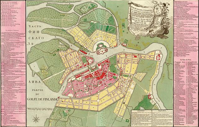
Русский: Novoi plan stolichnago goroda i krieposti Sanktpeterburga. Grid: Kh. M. Rot. Français : Nouveau plan de la ville et de la forteresse de St. Pétersbourg, exécuté exactement d'apres l'original qui se trouve dans les archives de la Police. Par C. M. Roth. English: New Map of the city and the fortress of St Petersburg, drawn exactly according to the original file in the archives of the Police. By C.M. Roth. |
||||
| თარიღი | |||||
| წყარო | Library of Congress Geography and Map Division Washington; http://memory.loc.gov/ammem/gmdhtml/gmdhome.html | ||||
| ავტორი | C. M. Roth. | ||||
| უფლება (ფაილის მეორეული გამოყენება) |
|
||||
| სხვა ვერსიები |
 |
||||

|
This map is available from the United States Library of Congress's Geography & Map Division
under the digital ID g7064s.ct001468. This tag does not indicate the copyright status of the attached work. A normal copyright tag is still required. See Commons:Licensing.
|
ფაილის ისტორია
დააწკაპუნეთ თარიღზე/დროზე ფაილის დასათვალიერებლად, როგორც ის მაშინ გამოიყურებოდა.
| თარიღი/დრო | მინიატიურა | ზომები | მომხმარებელი | შენიშვნა | |
|---|---|---|---|---|---|
| მიმდინარე | 05:49, 9 ნოემბერი 2006 | | 8 328×5 320 (6,99 მბ) | Balcer~commonswiki | Novoi plan stolichnago goroda i krieposti Sanktpeterburga. Nouveau plan de la ville et de la forteresse de St. Pétersbourg. Grid: Kh. M. Rot. Par C. M. Roth. Published in 1776. {{PD-LOC}} {{LOC-image|id=g7064s.ct001468 }} |
ბმულები
ამ ფაილზე ბმული მოცემულია შემდეგ გვერდებზე:
ფაილის გლობალური გამოყენება
ეს ფაილი გამოიყენება შემდეგ ვიკებში:
- გამოყენება bo.wikipedia.org-ში
- გამოყენება fi.wikipedia.org-ში
- გამოყენება fr.wikipedia.org-ში
- გამოყენება gl.wikipedia.org-ში
- გამოყენება pl.wikipedia.org-ში
- გამოყენება ru.wikipedia.org-ში
- გამოყენება uk.wikipedia.org-ში