ფაილი:Pluto-map-hs-2010-06-c180.jpg

ზომა წინასწარი გადახედვისას: 600 × 600 პიქსელი. სხვა გაფართოება: 240 × 240 პიქსელი | 480 × 480 პიქსელი | 768 × 768 პიქსელი | 1 200 × 1 200 პიქსელი.
თავდაპირველი ფაილი ((1 200 × 1 200 პიქსელი, ფაილის ზომა: 195 კბ, MIME ტიპი: image/jpeg))
| ეს ფაილი მდებარეობს Wikimedia Commons სერვერზე. იხილეთ მისი აღწერის გვერდი სრული ინფორმაციისთვის. |
 |
გადასვლა ფაილის გვერდზე |
რეზიუმე
| აღწერა |
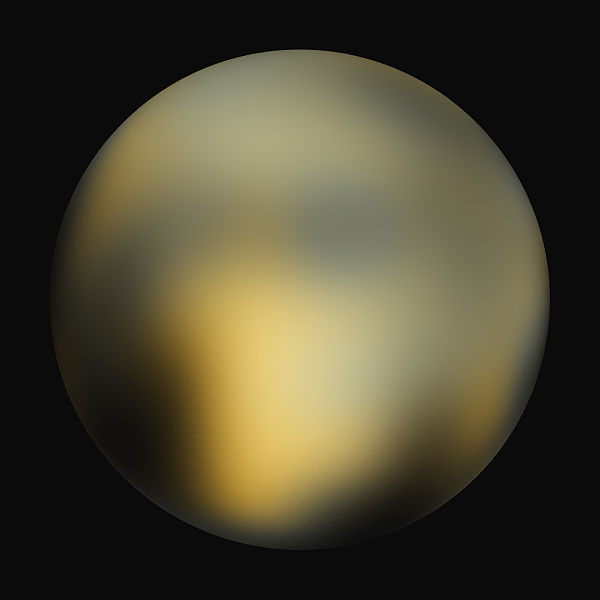
English: A best-fit color image/map of Pluto generated with the Hubble Space Telescope and advanced computers. It is unknown if the brightness differences are mountains, craters, or polar caps. |
| თარიღი | |
| წყარო | Hubblesite STScI-2010-06 (New Hubble Maps of Pluto Show Surface Changes; 180 degree Longitude) |
| ავტორი | NASA, ESA, and Marc W. Buie (Southwest Research Institute) |
| უფლება (ფაილის მეორეული გამოყენება) |
Any web pages, publications, or any other published use of these maps should provide a legible credit line consistent with the medium that states: "Images are courtesy of Marc W. Buie, Southwest Research Institute" |
ლიცენზია
| This file is in the public domain in the United States because it was solely created by NASA. NASA copyright policy states that "NASA material is not protected by copyright unless noted". (See Template:PD-USGov, NASA copyright policy page or JPL Image Use Policy.) | ||
 |
Warnings:
|
| Annotations | This image is annotated: View the annotations at Commons |
ფაილის ისტორია
დააწკაპუნეთ თარიღზე/დროზე ფაილის დასათვალიერებლად, როგორც ის მაშინ გამოიყურებოდა.
| თარიღი/დრო | მინიატიურა | ზომები | მომხმარებელი | შენიშვნა | |
|---|---|---|---|---|---|
| მიმდინარე | 23:42, 4 თებერვალი 2010 | | 1 200×1 200 (195 კბ) | Kheider | == Summary == {{Information |Description={{en|1=A best-fit color image/map of Pluto generated with the Hubble Space Telescope and advanced computers. It is unknown if the brightness differences are mountains, |
ბმულები
ამ ფაილზე ბმული მოცემულია შემდეგ გვერდებზე:
ფაილის გლობალური გამოყენება
ეს ფაილი გამოიყენება შემდეგ ვიკებში:
- გამოყენება ar.wikipedia.org-ში
- გამოყენება be.wikipedia.org-ში
- გამოყენება cs.wikipedia.org-ში
- გამოყენება cs.wikiversity.org-ში
- გამოყენება de.wikipedia.org-ში
- გამოყენება en.wikipedia.org-ში
- User:JohnOwens
- User:Clementi
- User:Steve Farrell
- User:DJRaveN4x
- User:Mitternacht90
- User:5aret/5aret's userboxes2
- User:Jimbobalina2005~enwiki
- User:Maelstromm
- User:Mckinlayr
- User:Andante1980
- User:Girla PurpleHeart
- User:Rwflammang
- User:Mathmagic
- User:Rursus
- User:Rkeysone
- User:MissionControl
- User:Buurma
- User:Thaimodz
- User:Lass Lethe
- User:Fjbfour
- User:Rursus/Pluto Dont Care Dwarf Planet Not
- User:Mekmtl
- User:Catalyst2007
- User:Praveen pillay
- User:Steve Farrell/userboxes
- User:Nincubus99x
- User:Cotard
- User:Mendors
- User:Derg999
- User:Radman622
- User:Pulsar06
- User:Themcman1/Userboxes
- User:Saber girl08/userboxen
- User:Andante1980/userbox
- User:Pastel kitten
- User:Countincr
- User:JCSeer
- User:Truncatedcone
- User:DareonClearwater
- User:LadyMage
- User:Samurai3
- User:Mandrke/UserBoxes
- User:Taskforce 58
იხილეთ, ამ ფაილის გლობალური გამოყენება.