ფაილი:Map of Constantinople (1422) by Florentine cartographer Cristoforo Buondelmonte.jpg
ზომა წინასწარი გადახედვისას: 476 × 600 პიქსელი. სხვა გაფართოება: 190 × 240 პიქსელი | 592 × 746 პიქსელი.
თავდაპირველი ფაილი ((592 × 746 პიქსელი, ფაილის ზომა: 838 კბ, MIME ტიპი: image/jpeg))
| ეს ფაილი მდებარეობს Wikimedia Commons სერვერზე. იხილეთ მისი აღწერის გვერდი სრული ინფორმაციისთვის. |
_by_Florentine_cartographer_Cristoforo_Buondelmonte.jpg?uselang=ka) |
გადასვლა ფაილის გვერდზე |
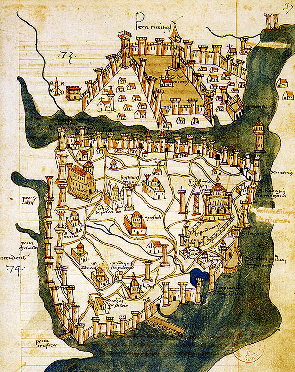
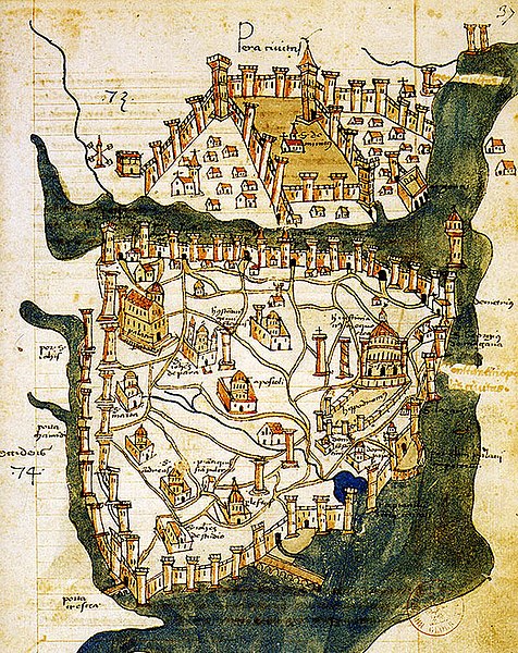
| აღწერა | Map of Constantinople (a small part of modern Istanbul), called "Historic Peninsula", Tarihi Yarımada en Turkish) designed in 1422 by Florentine cartographer Cristoforo Buondelmonti (Description des îles de l'archipel, Bibliothèque nationale, Paris) is the oldest surviving map of the city, and the only surviving map which predates the Turkish conquest of Constantinople in 1453. | ||||
| თარიღი | |||||
| წყარო | Liber insularum Archipelagi (1824), version available at the Bibliothèque nationale de France, Paris | ||||
| ავტორი | Cristoforo Buondelmonti | ||||
| უფლება (ფაილის მეორეული გამოყენება) |
|
||||
| სხვა ვერსიები |
|
||||

_by_Florentine_cartographer_Cristoforo_Buondelmonte.jpg)
ფაილის ისტორია
დააწკაპუნეთ თარიღზე/დროზე ფაილის დასათვალიერებლად, როგორც ის მაშინ გამოიყურებოდა.
| თარიღი/დრო | მინიატიურა | ზომები | მომხმარებელი | შენიშვნა | |
|---|---|---|---|---|---|
| მიმდინარე | 10:24, 25 ივნისი 2007 | | 592×746 (838 კბ) | M.K. | {{Information |Description=Map of Constantinople (1422) by Florentine cartographer Cristoforo Buondelmonte (''Description des îles de l'archipel'', Bibliothèque nationale, Paris) is the oldest surviving map of the city, and the only surviving ma |
ბმულები
ამ ფაილზე ბმული მოცემულია შემდეგ გვერდებზე:
ფაილის გლობალური გამოყენება
ეს ფაილი გამოიყენება შემდეგ ვიკებში:
- გამოყენება ar.wikipedia.org-ში
- გამოყენება az.wikipedia.org-ში
- გამოყენება ba.wikipedia.org-ში
- გამოყენება bg.wikipedia.org-ში
- გამოყენება ca.wikipedia.org-ში
- გამოყენება ce.wikipedia.org-ში
- გამოყენება cs.wikipedia.org-ში
- გამოყენება de.wikipedia.org-ში
- გამოყენება el.wikipedia.org-ში
- გამოყენება en.wikipedia.org-ში
- Bosporus
- Constantinople
- Constantine XI Palaiologos
- John VII Palaiologos
- Walls of Constantinople
- Beyoğlu
- Maiden's Tower
- Siege of Constantinople (1422)
- Siege of Constantinople (1411)
- Template:Did you know nominations/Kontoskalion
- Piyalepaşa, Beyoğlu
- Wikipedia:Main Page history/2019 February 23
- Siege of Constantinople (1394–1402)
- გამოყენება es.wikipedia.org-ში
- გამოყენება et.wikipedia.org-ში
- გამოყენება eu.wikipedia.org-ში
- გამოყენება fa.wikipedia.org-ში
- გამოყენება frp.wikipedia.org-ში
- გამოყენება fr.wikipedia.org-ში
იხილეთ, ამ ფაილის გლობალური გამოყენება.
_by_Florentine_cartographer_Cristoforo_Buondelmonte.jpg)
_by_Florentine_cartographer_Cristoforo_Buondelmonte.jpg)