ფაილი:Kandahar districts.png

ზომა წინასწარი გადახედვისას: 786 × 600 პიქსელი. სხვა გაფართოება: 315 × 240 პიქსელი | 629 × 480 პიქსელი | 1 000 × 763 პიქსელი.
თავდაპირველი ფაილი ((1 000 × 763 პიქსელი, ფაილის ზომა: 30 კბ, MIME ტიპი: image/png))
| ეს ფაილი მდებარეობს Wikimedia Commons სერვერზე. იხილეთ მისი აღწერის გვერდი სრული ინფორმაციისთვის. |
 |
გადასვლა ფაილის გვერდზე |

|
უცნობი ტიპის «locator map» ეს გამოსახულება უნდა იყოს გადახატული .svg ფორმატში. ყოველივე ეს გვაძლევს რამდენიმე მოგებას, რის შესახებაც შეგიძლიათ წაიკითხოთ Commons:Media for cleanup. თუ თქვენ უკვე გაქვთ .svg ვერსია, ძალიან გთხოვთ ატვირთოთ იგი. ატვირთვის შემდეგ გთხოვთ შეცვალოთ ეს თარგი შემდეგით - {{Vector version available|ფაილის სახელი.svg}}.
|
რეზიუმე
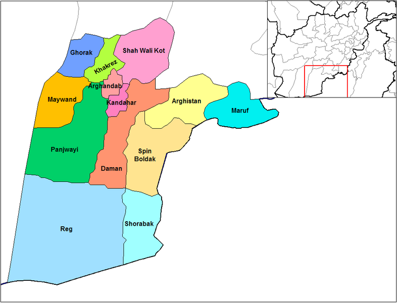
English: Map of the districts of Kandahar province of Afghanistan. Created by Rarelibra 19:26, 29 March 2007 (UTC) for public domain use, using MapInfo Professional v8.5 and various mapping resources.
ლიცენზია
| მე, ამ ნამუშევრის საავტორო უფლების მფლობელი, გადავცემ მას საზოგადოებრივ დომენში. ეს უფლება ვრცელდება მთელი მსოფლიოს მასშტაბით. ზოგიერთ ქვეყანაში ეს შეიძლება იურიდიულად შეუძლებელი იყოს, ასეთ შემთხვევაში: მე ვაძლევ უფლებას ნებისმიერს, რათა გამოიყენონ ეს ნამუშევარი ნებისმიერი მიზნით, ყოველგვარი წინაპირობის გარეშე, გარდა კანონით გათვალისწინებული შემთხვევებისა. |
ფაილის ისტორია
დააწკაპუნეთ თარიღზე/დროზე ფაილის დასათვალიერებლად, როგორც ის მაშინ გამოიყურებოდა.
| თარიღი/დრო | მინიატიურა | ზომები | მომხმარებელი | შენიშვნა | |
|---|---|---|---|---|---|
| მიმდინარე | 14:47, 15 თებერვალი 2024 | | 1 000×763 (30 კბ) | User-duck | Cropped 5 % horizontally, 6 % vertically using CropTool with lossless mode. |
| 19:26, 29 მარტი 2007 |  | 1 056×816 (30 კბ) | Rarelibra | Map of the districts of Kandahar province of Afghanistan. Created by ~~~~ for public domain use, using MapInfo Professional v8.5 and various mapping resources. |
ბმულები
ეს ფაილი არცერთ გვერდზე არ გამოიყენება.
ფაილის გლობალური გამოყენება
ეს ფაილი გამოიყენება შემდეგ ვიკებში:
- გამოყენება ar.wikipedia.org-ში
- გამოყენება bn.wikipedia.org-ში
- გამოყენება ca.wikipedia.org-ში
- გამოყენება da.wikipedia.org-ში
- გამოყენება de.wikipedia.org-ში
- გამოყენება en.wikipedia.org-ში
- გამოყენება en.wikinews.org-ში
- გამოყენება es.wikipedia.org-ში
- გამოყენება et.wikipedia.org-ში
- გამოყენება fr.wikipedia.org-ში
- გამოყენება he.wikipedia.org-ში
- გამოყენება incubator.wikimedia.org-ში
- გამოყენება it.wikipedia.org-ში
- გამოყენება ja.wikipedia.org-ში
- გამოყენება lt.wikipedia.org-ში
- გამოყენება mn.wikipedia.org-ში
- გამოყენება ms.wikipedia.org-ში
- გამოყენება nl.wikipedia.org-ში
იხილეთ, ამ ფაილის გლობალური გამოყენება.