ფაილი:Europe 1783-1792 en.png

ზომა წინასწარი გადახედვისას: 800 × 570 პიქსელი. სხვა გაფართოება: 320 × 228 პიქსელი | 640 × 456 პიქსელი | 1 024 × 730 პიქსელი | 1 280 × 913 პიქსელი | 2 560 × 1 825 პიქსელი | 3 872 × 2 761 პიქსელი.
თავდაპირველი ფაილი ((3 872 × 2 761 პიქსელი, ფაილის ზომა: 1,24 მბ, MIME ტიპი: image/png))
| ეს ფაილი მდებარეობს Wikimedia Commons სერვერზე. იხილეთ მისი აღწერის გვერდი სრული ინფორმაციისთვის. |
 |
გადასვლა ფაილის გვერდზე |
_en.png)
.png)
.jpg)
რეზიუმე
| აღწერა |
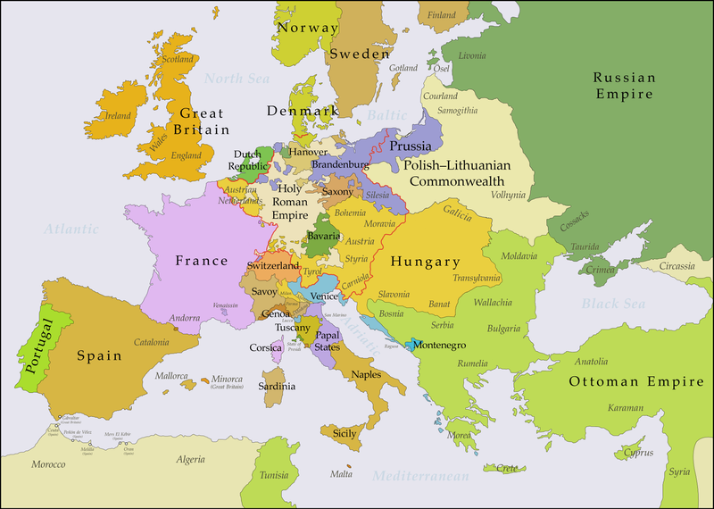
English: This map shows Europe in the years between the 1783 Russian annexation of Crimea after the Russo-Turkish War of 1768–1774 and the Russian annexation of Yedisan in 1792 at the end of the Russo-Turkish War of 1787–1792. The red line marks the borders of the Holy Roman Empire. The work was created with Inkscape and is mainly based on a map in: Putzger - Historischer Weltatlas, Berlin 1990, 78 pp. |
| თარიღი | |
| წყარო | პირადი ნამუშევარი, based on File:Europe 1748-1766 en.png |
| ავტორი | Bryan Rutherford |
ლიცენზია
მე, ამ ნამუშევარზე საავტორო უფლებების მფლობელი, ვაქვეყნებ მას შემდეგი ლიცენზიით:
This file is licensed under the Creative Commons Attribution-Share Alike 4.0 International license.
- თქვენ თავისუფლად შეგიძლიათ:
- ნამუშევრის გაზიარება – ნამუშევრის კოპირება, გავრცელება და გადაცემა.
- შექმნათ დაფუძნებულები – ნამუშევრის შესწორება
- შემდეგი პირობებით:
- მოხსენიება – თქვენ უნდა მიუთითოთ წყაროს შემქმნელი იმ გზით, რომელიც დანიშნა ავტორმა ან საავტორო უფლებების მფლობელმა. მაგრამ არა ისე, თითქოს წყაროს ავტორი მხარს გიჭერთ თქვენ ან დაუჭირა თქვენს მიერ შექმნილ ნაწარმოებს.
- გავრცელება იგივე პირობებეით – თუ თქვენ ცვლით, ან ქმნით ახალ ნაშრომს ამ ნამუშევრის გამოყენებთ, თქვენ გაქვთ უფლება გაავრცელოთ იგი იგივე ან შესაბამისი ლიცენზიით, რომლითაც ვრცელდება წყარო.
| Annotations | This image is annotated: View the annotations at Commons |
ფაილის ისტორია
დააწკაპუნეთ თარიღზე/დროზე ფაილის დასათვალიერებლად, როგორც ის მაშინ გამოიყურებოდა.
| თარიღი/დრო | მინიატიურა | ზომები | მომხმარებელი | შენიშვნა | |
|---|---|---|---|---|---|
| მიმდინარე | 21:47, 15 ივლისი 2018 | | 3 872×2 761 (1,24 მბ) | Bryanrutherford0 | Added the Ionian Islands, made the Duchy of Milan a Habsburg possession, gave Prussia control of Mansfeld (1780) |
| 02:29, 10 ივლისი 2018 |  | 3 872×2 761 (1,23 მბ) | Bryanrutherford0 | Added Comtat Venaissin and redrew borders of Neuchâtel, Bishopric Basel, and Montbéliard | |
| 00:46, 3 ოქტომბერი 2017 |  | 3 872×2 761 (1,23 მბ) | Bryanrutherford0 | Transferred control of Saaremaa and Hiiumaa to Russia (1721 Treaty of Nystad), transferred control of Corsica to France (1769 [[:en:French conquest of Corsica|French conquest of... | |
| 15:03, 30 სექტემბერი 2017 |  | 3 872×2 761 (1,23 მბ) | Bryanrutherford0 | Adjusted Russian-Swedish border in Finland to reflect Russian gains in the 1743 Treaty of Åbo after the Russo-Swedish War. | |
| 04:47, 30 სექტემბერი 2017 |  | 3 872×2 761 (1,23 მბ) | Bryanrutherford0 | User created page with UploadWizard |
ბმულები
ამ ფაილზე ბმული მოცემულია შემდეგ გვერდებზე:
ფაილის გლობალური გამოყენება
ეს ფაილი გამოიყენება შემდეგ ვიკებში:
- გამოყენება ar.wikipedia.org-ში
- გამოყენება bg.wikipedia.org-ში
- გამოყენება bn.wikipedia.org-ში
- გამოყენება br.wikipedia.org-ში
- გამოყენება ca.wikipedia.org-ში
- გამოყენება el.wikipedia.org-ში
- გამოყენება en.wikipedia.org-ში
- გამოყენება es.wikipedia.org-ში
- გამოყენება fi.wikipedia.org-ში
- გამოყენება fr.wikipedia.org-ში
- გამოყენება it.wikipedia.org-ში
- გამოყენება ja.wikipedia.org-ში
- გამოყენება mk.wikipedia.org-ში
- გამოყენება sl.wikipedia.org-ში
- გამოყენება th.wikipedia.org-ში
- გამოყენება tl.wikipedia.org-ში
- გამოყენება uz.wikipedia.org-ში
- გამოყენება vi.wikipedia.org-ში
- გამოყენება zh.wikipedia.org-ში