თავდაპირველი ფაილი ((6 000 × 4 998 პიქსელი, ფაილის ზომა: 50,86 მბ, MIME ტიპი: image/png))

ეს ფაილი მდებარეობს Wikimedia Commons სერვერზე.
იხილეთ მისი აღწერის გვერდი სრული ინფორმაციისთვის.
გადასვლა ფაილის გვერდზე

რეზიუმე

აღწერა
English: This uses these two public domain source images:
  • File:Piri reis world map 01.jpg
  • File:Cantino planisphere (1502).jpg

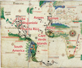
The black lines are derived from the Piri Reis 1513 map fragment. Red captions label places depicted in similar locations on both maps. The position of Africa's Atlantic coast and the Atlantic islands are very similar. Europe is roughly similar. The position of South America is similar in both maps, but the Piri Reis map has considerably more detail. There is debate over what the islands and bays bordering Piri Reis' Atlantic represent. The Cantino Planisphere depicts the Caribbean according to the 1500 map of Juan de la Cosa. Piri Reis depicts the Carribean based on an earlier lost map from Columbus, reflecting Columbus' belief that Cuba was part of Asian mainland and that the island of Hispaniola was Cipango, Marco Polo's Japan, depicted on contemporary maps of Asia. The peninsula extending from an American mainland in the Planisphere may be based on the "mainland" Cuba misconception. The areas North and West of Brittany were on portions of the Piri Reis map thought to be lost.

Place names in the Caribbean:

  • Puerto Rico: boriquem (Boriquén, the native Taíno name for Puerto Rico), Sanjuwano bastido (San Juan Bastido, an early name for Puerto Rico)
  • Hispaniola: ilha espanholia (Isle Hispaniola), Elcezire Izle despanya (The Island called Isla de Españiola)
  • Cuba: Ilha Yssabella (Isle Isabella), Porta Ghande (Puerto Grande, an early name for Guantanamo Bay)
  • Red text overlay, text visible from Cantino Planisphere, text transliterated from the Piri Reis map

Additional sources:

  • Gaspar, Joaquim Alves (2015), "The Representation of the West Indies in Early Iberian Cartography: A Cartometric Approach", Terrae Incognitae, 47 (1): 10-32, doi:10.1179/0082288415Z.00000000041 .
  • McIntosh, Gregory C. (2000), The Piri Reis Map of 1513, Athens, Georgia: University of Georgia Press, ISBN 0-8203-2157-5.
  • Soucek, Svat (1996), Piri Reis and Turkish Mapmaking after Columbus: The Khalili Portolan Atlas, London and New York: Nour Foundation and Azimuth Editions.
  • Vescelius, Gary S., Cinquino, Michael A., Tronolone, Carmine and Vandrei, Charles (2007), "Historic Resources on the Vieques Naval Reservation and the Historical Development of Vieques Island", Ecology and Environment: Puerto Rico.
თარიღი
წყარო პირადი ნამუშევარი
ავტორი Rjjiii

ლიცენზია

მე, ამ ნამუშევარზე საავტორო უფლებების მფლობელი, ვაქვეყნებ მას შემდეგი ლიცენზიით:
w:ka:Creative Commons
მოხსენიება გავრცელება იგივე პირობებეით
This file is licensed under the Creative Commons Attribution-Share Alike 4.0 International license.
თქვენ თავისუფლად შეგიძლიათ:
  • ნამუშევრის გაზიარება – ნამუშევრის კოპირება, გავრცელება და გადაცემა.
  • შექმნათ დაფუძნებულები – ნამუშევრის შესწორება
შემდეგი პირობებით:
  • მოხსენიება – თქვენ უნდა მიუთითოთ წყაროს შემქმნელი იმ გზით, რომელიც დანიშნა ავტორმა ან საავტორო უფლებების მფლობელმა. მაგრამ არა ისე, თითქოს წყაროს ავტორი მხარს გიჭერთ თქვენ ან დაუჭირა თქვენს მიერ შექმნილ ნაწარმოებს.
  • გავრცელება იგივე პირობებეით – თუ თქვენ ცვლით, ან ქმნით ახალ ნაშრომს ამ ნამუშევრის გამოყენებთ, თქვენ გაქვთ უფლება გაავრცელოთ იგი იგივე ან შესაბამისი ლიცენზიით, რომლითაც ვრცელდება წყარო.

Captions

Add a one-line explanation of what this file represents
A comparison of the 1513 Piri Reis map (black lines) against a section of the 1503 Cantino Planisphere

source of file ინგლისური

original creation by uploader ინგლისური

media type ინგლისური

image/png

checksum ინგლისური

7bc419952d8c2562f40c5ace6749c56a4fff056b

data size ინგლისური

53325456 ბაიტი

ფაილის ისტორია

დააწკაპუნეთ თარიღზე/დროზე ფაილის დასათვალიერებლად, როგორც ის მაშინ გამოიყურებოდა.

თარიღი/დრომინიატიურაზომებიმომხმარებელიშენიშვნა
მიმდინარე02:42, 30 ივლისი 2023მინიატურა 02:42, 30 ივლისი 2023 ვერსიისთვის6 000×4 998 (50,86 მბ)RjjiiiSubtle cleanup
18:43, 29 ივლისი 2023მინიატურა 18:43, 29 ივლისი 2023 ვერსიისთვის6 000×4 998 (50,85 მბ)RjjiiiMake text more legible, especially in thumbnails
19:03, 13 მაისი 2023მინიატურა 19:03, 13 მაისი 2023 ვერსიისთვის6 000×4 998 (57,78 მბ)Rjjiiibetter visibility and color fidelity
18:37, 13 მაისი 2023მინიატურა 18:37, 13 მაისი 2023 ვერსიისთვის6 000×4 998 (42,51 მბ)RjjiiiUploaded own work with UploadWizard

ამ ფაილზე ბმული მოცემულია შემდეგ გვერდებზე:

ფაილის გლობალური გამოყენება

ეს ფაილი გამოიყენება შემდეგ ვიკებში:

მეტამონაცემები