ფაილი:Challenger Deep EM124 Sonar Map and Diving History 101119.jpg
ზომა წინასწარი გადახედვისას: 800 × 366 პიქსელი. სხვა გაფართოება: 320 × 146 პიქსელი | 640 × 292 პიქსელი | 1 278 × 584 პიქსელი.
თავდაპირველი ფაილი ((1 278 × 584 პიქსელი, ფაილის ზომა: 141 კბ, MIME ტიპი: image/jpeg))
| ეს ფაილი მდებარეობს Wikimedia Commons სერვერზე. იხილეთ მისი აღწერის გვერდი სრული ინფორმაციისთვის. |
 |
გადასვლა ფაილის გვერდზე |
რეზიუმე
| აღწერა |
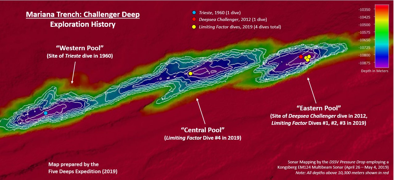
English: This map was created by the DSSV Pressure Drop's Kngsberg EM124 sonar system over the course of two weeks to map the Challenger Deep in the Marianas Trench. The Deep consists of three "pools" of varying depth with the central pool being the most shallow, then the western one, with the eastern pool measured to be the deepest at 10,925 meters. That depth was measured using the manned submersible DSV Limiting Factor on April 28 - May 3, 2019 as part of the Five Deeps Expedition. |
| თარიღი | |
| წყარო | პირადი ნამუშევარი |
| ავტორი | Vlvescovo |
ლიცენზია
მე, ამ ნამუშევარზე საავტორო უფლებების მფლობელი, ვაქვეყნებ მას შემდეგი ლიცენზიით:
This file is licensed under the Creative Commons Attribution-Share Alike 4.0 International license.
- თქვენ თავისუფლად შეგიძლიათ:
- ნამუშევრის გაზიარება – ნამუშევრის კოპირება, გავრცელება და გადაცემა.
- შექმნათ დაფუძნებულები – ნამუშევრის შესწორება
- შემდეგი პირობებით:
- მოხსენიება – თქვენ უნდა მიუთითოთ წყაროს შემქმნელი იმ გზით, რომელიც დანიშნა ავტორმა ან საავტორო უფლებების მფლობელმა. მაგრამ არა ისე, თითქოს წყაროს ავტორი მხარს გიჭერთ თქვენ ან დაუჭირა თქვენს მიერ შექმნილ ნაწარმოებს.
- გავრცელება იგივე პირობებეით – თუ თქვენ ცვლით, ან ქმნით ახალ ნაშრომს ამ ნამუშევრის გამოყენებთ, თქვენ გაქვთ უფლება გაავრცელოთ იგი იგივე ან შესაბამისი ლიცენზიით, რომლითაც ვრცელდება წყარო.
ფაილის ისტორია
დააწკაპუნეთ თარიღზე/დროზე ფაილის დასათვალიერებლად, როგორც ის მაშინ გამოიყურებოდა.
| თარიღი/დრო | მინიატიურა | ზომები | მომხმარებელი | შენიშვნა | |
|---|---|---|---|---|---|
| მიმდინარე | 22:06, 11 ოქტომბერი 2019 | | 1 278×584 (141 კბ) | Vlvescovo | User created page with UploadWizard |
ბმულები
ამ ფაილზე ბმული მოცემულია შემდეგ გვერდებზე:
ფაილის გლობალური გამოყენება
ეს ფაილი გამოიყენება შემდეგ ვიკებში:
- გამოყენება ar.wikipedia.org-ში
- გამოყენება de.wikipedia.org-ში
- გამოყენება en.wikipedia.org-ში
- გამოყენება ga.wikipedia.org-ში
- გამოყენება lv.wikipedia.org-ში
- გამოყენება pl.wikipedia.org-ში