ფაილი:British Isles.svg

ამ SVG ფაილის PNG წინასწარი გადახედვის ზომაა: 361 × 600 პიქსელი. სხვა გაფართოება: 144 × 240 პიქსელი | 289 × 480 პიქსელი | 462 × 768 პიქსელი | 616 × 1 024 პიქსელი | 1 232 × 2 048 პიქსელი | 1 300 × 2 160 პიქსელი.
თავდაპირველი ფაილი (ფაილი SVG, ნომინალურად 1 300 × 2 160 პიქსელი, ფაილის ზომა: 154 კბ)
| ეს ფაილი მდებარეობს Wikimedia Commons სერვერზე. იხილეთ მისი აღწერის გვერდი სრული ინფორმაციისთვის. |
 |
გადასვლა ფაილის გვერდზე |
რეზიუმე
| აღწერა |
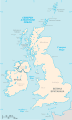
An SVG map of the British Isles, with the largest islands and archipelagos labelled. Always considered part of the British Isles
Sometimes considered part of the British Isles
Other lands |
| წყარო | პირადი ნამუშევარი |
| ავტორი | Smurrayinchester |
| SVG genesis | This W3C-invalid map was created with unknown tool. This map is translated using SVG switch elements: all translations are stored in the same file. |
}
ლიცენზია
მე, ამ ნამუშევარზე საავტორო უფლებების მფლობელი, ვაქვეყნებ მას შემდეგი ლიცენზიით:

|
თქვენ შეგიძიათ გაავრცელოთ ან შეცვალოთ დოკუმენტი GNU Free Documentation ლიცენზიის 1.2 ან უფრო გვიანდელი ვერსიის პირობების თანახმად, რომელიც გამოქვეყნებულია თავისუფალი პროგრამული უზრუნველყოფის ფონდის მიერ, შეუცვლელი განყოფილებების გარეშე, პირველ და ბოლო გვერდებზე განთავსებულ ტექსტებზე. ლიცენზიის ასლი არის განთავსებული განყოფილებაში სახელად GNU Free Documentation License. |
| ეს ნამუშევარი ვრცელდება Creative Commons Attribution-Share Alike 3.0 Unported ლიცენზიით. | ||
| ||
| ეს ლიცენზირების ნიშანი დაემატა ამ ფაილს, როგორც GFDL ლიცენზიის განახლების ნაწილი. |
Derivative works
-
 македонски
 -
 Flag map (1801–1922)


derivative works
Derivative works of this file: British Isles mk.svg
ფაილის ისტორია
დააწკაპუნეთ თარიღზე/დროზე ფაილის დასათვალიერებლად, როგორც ის მაშინ გამოიყურებოდა.
| თარიღი/დრო | მინიატიურა | ზომები | მომხმარებელი | შენიშვნა | |
|---|---|---|---|---|---|
| მიმდინარე | 15:33, 10 თებერვალი 2019 | | 1 300×2 160 (154 კბ) | MSG17 | Uploaded from SVG Translate. |
| 14:56, 13 ოქტომბერი 2018 |  | 1 300×2 160 (141 კბ) | Seb35 | small bug: translations have to be before the default text else the PNG rendering selects the default text | |
| 14:51, 13 ოქტომბერი 2018 |  | 1 300×2 160 (141 კბ) | Seb35 | added French translation | |
| 14:50, 20 მაისი 2014 |  | 1 300×2 160 (135 კბ) | NikNaks | More cleaning. File could still be a lot smaller than it currently is | |
| 03:02, 20 მაისი 2014 |  | 1 300×2 160 (152 კბ) | NikNaks | Malay translation | |
| 02:36, 20 მაისი 2014 |  | 1 300×2 160 (148 კბ) | NikNaks | Cleaning unfortunately lost detail. Will have to return to later | |
| 02:22, 20 მაისი 2014 |  | 1 297×2 160 (37 კბ) | NikNaks | Attempting to clean up the file before translation | |
| 12:37, 20 აგვისტო 2006 |  | 1 297×2 160 (196 კბ) | Smurrayinchester | An SVG map of the British Isles, with the largest islands and archipelagos labeled. {{legend|#fff0de|Always considered part of the British Isles|border=#ffffff}} {{legend|#ffb380|Sometimes considered part of the British Isles|border=#ffffff}} {{legend|#e |
ბმულები
ამ ფაილზე ბმული მოცემულია შემდეგ გვერდებზე:
ფაილის გლობალური გამოყენება
ეს ფაილი გამოიყენება შემდეგ ვიკებში:
- გამოყენება ar.wikipedia.org-ში
- გამოყენება az.wikipedia.org-ში
- გამოყენება be.wikipedia.org-ში
- გამოყენება bs.wikipedia.org-ში
- გამოყენება ceb.wikipedia.org-ში
- გამოყენება ckb.wikipedia.org-ში
- გამოყენება da.wikipedia.org-ში
- გამოყენება en.wikipedia.org-ში
- Geography of the Isle of Man
- Burhou
- Talk:International Football Association Board
- Module:Location map/data/British Isles/doc
- List of offshore wind farms in the Irish Sea
- Siege of St Andrews Castle
- User:Malpass93/sandbox
- Module:Location map/data/British Isles
- 2014 Senior Open Championship
- 2017 Senior Open Championship
- 2018 Eisenhower Trophy
- User:Grover cleveland/History of the laws of the game/List of IFAB meetings
- User:Grover cleveland/English managers
- 2018 Espirito Santo Trophy
- 1965 European Amateur Team Championship
- 1975 European Amateur Team Championship
- 1981 European Amateur Team Championship
- 1989 European Amateur Team Championship
- 1997 European Amateur Team Championship
- 2005 European Amateur Team Championship
- 2007 European Amateur Team Championship
- 2009 European Amateur Team Championship
- 1971 European Ladies' Team Championship
- 1979 European Ladies' Team Championship
- 1987 European Ladies' Team Championship
- 1991 European Ladies' Team Championship
- 2013 European Ladies' Team Championship
- 2021 European Ladies' Team Championship
- 2022 European Amateur Team Championship
- 2022 European Ladies' Team Championship
- 2013 Senior Open Championship
- 2012 Senior Open Championship
- 2011 Senior Open Championship
- 2008 Senior Open Championship
- 2006 Senior Open Championship
- 2002 Senior British Open
- 2001 Senior British Open
- 2000 Senior British Open
- 2022 Senior Open Championship
- User:Erik Sergeant/sandbox 2
- 2023 Senior Open Championship
- Module:Location map/data/British Isles/sandbox
- Draft:2024 Monoposto Championship
იხილეთ, ამ ფაილის გლობალური გამოყენება.