ფაილი:1939 IND Second System.jpg
თავდაპირველი ფაილი ((2 162 × 3 055 პიქსელი, ფაილის ზომა: 1,13 მბ, MIME ტიპი: image/jpeg))
| ეს ფაილი მდებარეობს Wikimedia Commons სერვერზე. იხილეთ მისი აღწერის გვერდი სრული ინფორმაციისთვის. |
 |
გადასვლა ფაილის გვერდზე |
რეზიუმე
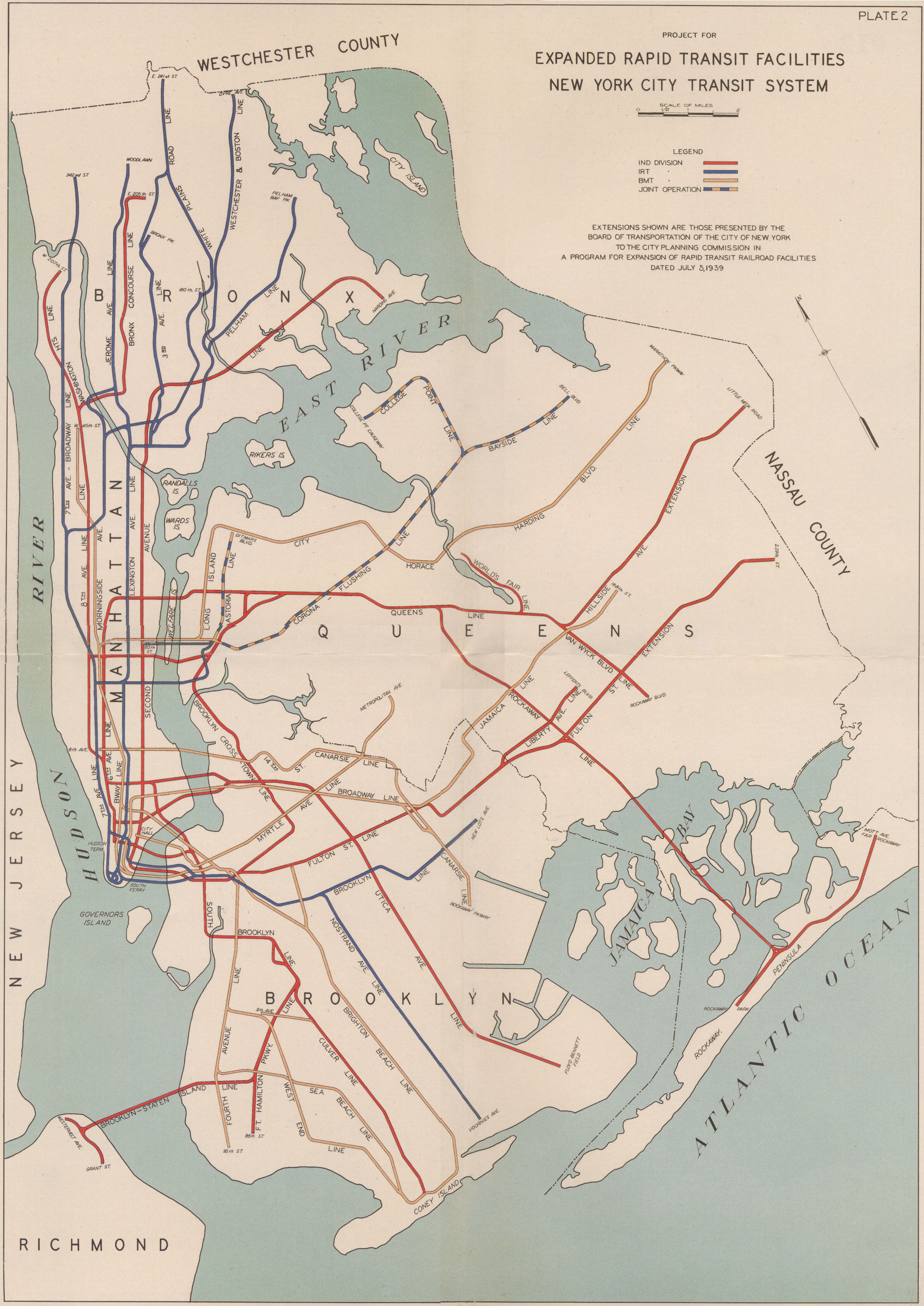
1939 NYC Subway expansion plans (IND Second System), reproduced in Twelve Historical New York City Street and Transit Maps Volume II from 1847-1939. No copyright notice, which was required in the U.S. until 1989, so it's public domain. Also not listed in [1] archive copy at the Wayback Machine.
ლიცენზია
|
This work is in the public domain in its country of origin and other countries and areas where the copyright term is the author's life plus 70 years or fewer.
| |
| This file has been identified as being free of known restrictions under copyright law, including all related and neighboring rights. | |
ფაილის ისტორია
დააწკაპუნეთ თარიღზე/დროზე ფაილის დასათვალიერებლად, როგორც ის მაშინ გამოიყურებოდა.
| თარიღი/დრო | მინიატიურა | ზომები | მომხმარებელი | შენიშვნა | |
|---|---|---|---|---|---|
| მიმდინარე | 00:32, 5 მარტი 2005 | | 2 162×3 055 (1,13 მბ) | SPUI~commonswiki | {{PD}}1939 NYC Subway expansion plans (IND Second System), reproduced in ''Twelve Historical New York City Street and Transit Maps Volume II from 1847-1939''. No copyright notice, which was required in the U.S. until 1989, so it's public domain.[[category |
ბმულები
ეს ფაილი არცერთ გვერდზე არ გამოიყენება.
ფაილის გლობალური გამოყენება
ეს ფაილი გამოიყენება შემდეგ ვიკებში:
- გამოყენება en.wikipedia.org-ში
- Proposed expansion of the New York City Subway
- Flushing–Main Street station (IRT Flushing Line)
- History of the New York City Subway
- User:Alphachimp/Photos/NYCT
- Staten Island Tunnel
- New York City Subway map
- Portal:Trains/Selected article/2017 archive
- Portal:Trains/Selected article/Week 5, 2017
- Unbuilt plans for the Second Avenue Subway
- გამოყენება es.wikipedia.org-ში
- გამოყენება eu.wikipedia.org-ში
- გამოყენება fr.wikipedia.org-ში
- გამოყენება it.wikipedia.org-ში
- გამოყენება ja.wikipedia.org-ში
- გამოყენება zh.wikipedia.org-ში