ფაილი:Tambora volcano.jpg
უფრო მაღალი გარჩევადობა არ არის შესაძლებელი.
Tambora_volcano.jpg ((640 × 436 პიქსელი, ფაილის ზომა: 67 კბ, MIME ტიპი: image/jpeg))
| ეს ფაილი მდებარეობს Wikimedia Commons სერვერზე. იხილეთ მისი აღწერის გვერდი სრული ინფორმაციისთვის. |
 |
გადასვლა ფაილის გვერდზე |
რეზიუმე
| აღწერა |
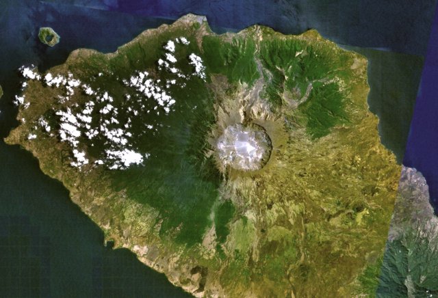
English: Tambora volcano on Indonesia's Sumbawa Island was the site of the world's largest historical eruption in April 1815. This NASA Landsat mosaic shows the 6-km-wide caldera truncating the 2850-m-high summit of the massive volcano. Pyroclastic flows during the 1815 eruption reached the sea on all sides of the 60-km-wide volcanic peninsula, and the ejection of large amounts of tephra caused world-wide temperature declines in 1815 and 1816. |
| თარიღი | უცნობი თარიღი |
| წყარო | http://www.volcano.si.edu/world/volcano.cfm?vnum=0604-04=&volpage=photos&photo=115009 |
| ავტორი | NASA Landsat7 image (worldwind.arc.nasa.gov) |
ლიცენზია
| This image is in the public domain because it is a screenshot from NASA’s globe software World Wind using a public domain layer, such as Blue Marble, MODIS, Landsat, SRTM, USGS or GLOBE.
|
 |
ფაილის ისტორია
დააწკაპუნეთ თარიღზე/დროზე ფაილის დასათვალიერებლად, როგორც ის მაშინ გამოიყურებოდა.
| თარიღი/დრო | მინიატიურა | ზომები | მომხმარებელი | შენიშვნა | |
|---|---|---|---|---|---|
| მიმდინარე | 22:29, 29 ივლისი 2010 | | 640×436 (67 კბ) | Michael Metzger | {{Information |Description={{en|1=Tambora volcano on Indonesia's Sumbawa Island was the site of the world's largest historical eruption in April 1815. This NASA Landsat mosaic shows the 6-km-wide caldera truncating the 2850-m-high summit of the massive vo |
ბმულები
ამ ფაილზე ბმული მოცემულია შემდეგ გვერდებზე:
ფაილის გლობალური გამოყენება
ეს ფაილი გამოიყენება შემდეგ ვიკებში:
- გამოყენება de.wikipedia.org-ში
- გამოყენება en.wikiversity.org-ში
- გამოყენება fr.wikipedia.org-ში
- გამოყენება ja.wikipedia.org-ში
- გამოყენება nl.wikipedia.org-ში
- გამოყენება oc.wikipedia.org-ში