ფაილი:Rospuda Valley, Poland.jpg

ზომა წინასწარი გადახედვისას: 800 × 533 პიქსელი. სხვა გაფართოება: 320 × 213 პიქსელი | 640 × 427 პიქსელი | 1 024 × 683 პიქსელი | 1 280 × 853 პიქსელი | 3 000 × 2 000 პიქსელი.
თავდაპირველი ფაილი ((3 000 × 2 000 პიქსელი, ფაილის ზომა: 3,25 მბ, MIME ტიპი: image/jpeg))
| ეს ფაილი მდებარეობს Wikimedia Commons სერვერზე. იხილეთ მისი აღწერის გვერდი სრული ინფორმაციისთვის. |
 |
გადასვლა ფაილის გვერდზე |
რეზიუმე
| აღწერა |
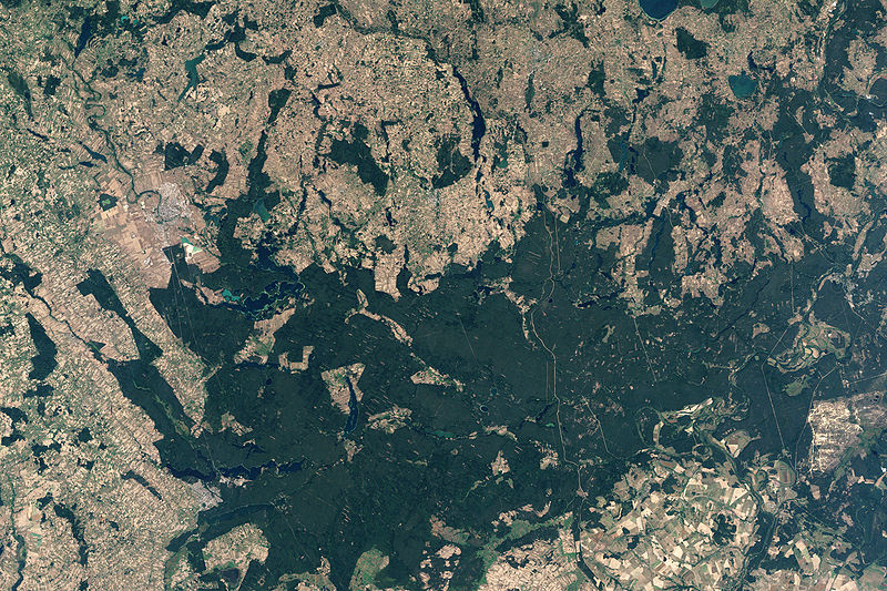
English: NASA’s Landsat 7 satellite captured this image of Rospuda Valley. This true-color image shows a patchwork of peat bog and agricultural fields. In contrast to the nearly uniform deep-green wetlands, the fields appear as close-knit rectangles of varied shades of green and beige. Rospuda River meanders between cultivated fields in the northwest and wetland territory in the southeast, connecting with Lake Necko. Numerous other lakes and ponds appear north and east of Lake Necko, some of them overlapping agricultural areas. |
| თარიღი | |
| წყარო | NASA Earth Observatory |
| ავტორი | Jesse Allen |
NASA image created by Jesse Allen, using Landsat data provided by the United States Geological Survey.
ლიცენზია
| This file is in the public domain in the United States because it was solely created by NASA. NASA copyright policy states that "NASA material is not protected by copyright unless noted". (See Template:PD-USGov, NASA copyright policy page or JPL Image Use Policy.) | ||
 |
Warnings:
|
ფაილის ისტორია
დააწკაპუნეთ თარიღზე/დროზე ფაილის დასათვალიერებლად, როგორც ის მაშინ გამოიყურებოდა.
| თარიღი/დრო | მინიატიურა | ზომები | მომხმარებელი | შენიშვნა | |
|---|---|---|---|---|---|
| მიმდინარე | 13:34, 19 აპრილი 2009 | | 3 000×2 000 (3,25 მბ) | Originalwana | {{Information |Description={{en|1=NASA’s Landsat 7 satellite captured this image of Rospuda Valley. This true-color image shows a patchwork of peat bog and agricultural fields. In contrast to the nearly uniform deep-green wetlands, the fields appear as |
ბმულები
ამ ფაილზე ბმული მოცემულია შემდეგ გვერდებზე:
ფაილის გლობალური გამოყენება
ეს ფაილი გამოიყენება შემდეგ ვიკებში:
- გამოყენება en.wikipedia.org-ში
- გამოყენება lt.wikipedia.org-ში
- გამოყენება ru.wikipedia.org-ში
- გამოყენება uk.wikipedia.org-ში
- გამოყენება zh.wikipedia.org-ში