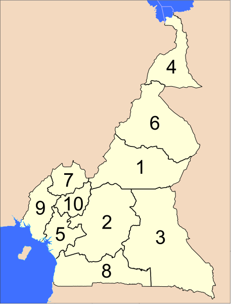
ფაილი:Provinces of Cameroon numbered.svg

ამ SVG ფაილის PNG წინასწარი გადახედვის ზომაა: 457 × 600 პიქსელი. სხვა გაფართოება: 183 × 240 პიქსელი | 366 × 480 პიქსელი | 585 × 768 პიქსელი | 780 × 1 024 პიქსელი | 1 561 × 2 048 პიქსელი | 586 × 769 პიქსელი.
თავდაპირველი ფაილი (ფაილი SVG, ნომინალურად 586 × 769 პიქსელი, ფაილის ზომა: 1,22 მბ)
ფაილის ისტორია
დააწკაპუნეთ თარიღზე/დროზე ფაილის დასათვალიერებლად, როგორც ის მაშინ გამოიყურებოდა.
| თარიღი/დრო | მინიატიურა | ზომები | მომხმარებელი | შენიშვნა | |
|---|---|---|---|---|---|
| მიმდინარე | 04:39, 10 აპრილი 2007 |  | 586×769 (1,22 მბ) | Interiot~commonswiki | The provinces of Cameroon. Modified from http://www.un.org/Depts/Cartographic/map/profile/cameroon.pdf {{UN map}} Category:SVG maps of Africa |
ბმულები
ამ ფაილზე ბმული მოცემულია შემდეგ გვერდებზე:
ფაილის გლობალური გამოყენება
ეს ფაილი გამოიყენება შემდეგ ვიკებში:
- გამოყენება ab.wikipedia.org-ში
- გამოყენება ar.wikipedia.org-ში
- გამოყენება bcl.wikipedia.org-ში
- გამოყენება be-tarask.wikipedia.org-ში
- გამოყენება be.wikipedia.org-ში
- გამოყენება bg.wikipedia.org-ში
- გამოყენება ca.wikipedia.org-ში
- გამოყენება cs.wikipedia.org-ში
- გამოყენება de.wikipedia.org-ში
- გამოყენება en.wikipedia.org-ში
- გამოყენება es.wikipedia.org-ში
- გამოყენება eu.wikipedia.org-ში
- გამოყენება fa.wikipedia.org-ში
- გამოყენება fi.wikipedia.org-ში
- გამოყენება guw.wikipedia.org-ში
- გამოყენება hr.wikipedia.org-ში
- გამოყენება id.wikipedia.org-ში
- გამოყენება ja.wikipedia.org-ში
- გამოყენება ko.wikipedia.org-ში
- გამოყენება li.wikipedia.org-ში
- გამოყენება lt.wikipedia.org-ში
- გამოყენება mk.wikipedia.org-ში
- გამოყენება mt.wikipedia.org-ში
- გამოყენება nl.wikipedia.org-ში
- გამოყენება no.wikipedia.org-ში
- გამოყენება pt.wikipedia.org-ში
- გამოყენება ru.wikipedia.org-ში
- გამოყენება sco.wikipedia.org-ში
- გამოყენება simple.wikipedia.org-ში
- გამოყენება si.wikipedia.org-ში
- გამოყენება sr.wikipedia.org-ში
- გამოყენება sv.wikipedia.org-ში
- გამოყენება tr.wikipedia.org-ში
- გამოყენება uk.wikipedia.org-ში
- გამოყენება ur.wikipedia.org-ში
- გამოყენება zh-min-nan.wikipedia.org-ში
- გამოყენება zh.wikipedia.org-ში

