ფაილი:PonticKingdom.png

ზომა წინასწარი გადახედვისას: 718 × 600 პიქსელი. სხვა გაფართოება: 287 × 240 პიქსელი | 575 × 480 პიქსელი | 919 × 768 პიქსელი | 1 226 × 1 024 პიქსელი | 1 551 × 1 296 პიქსელი.
თავდაპირველი ფაილი ((1 551 × 1 296 პიქსელი, ფაილის ზომა: 265 კბ, MIME ტიპი: image/png))
| ეს ფაილი მდებარეობს Wikimedia Commons სერვერზე. იხილეთ მისი აღწერის გვერდი სრული ინფორმაციისთვის. |
 |
გადასვლა ფაილის გვერდზე |

|
უცნობი ტიპის «historical map» ეს გამოსახულება უნდა იყოს გადახატული .svg ფორმატში. ყოველივე ეს გვაძლევს რამდენიმე მოგებას, რის შესახებაც შეგიძლიათ წაიკითხოთ Commons:Media for cleanup. თუ თქვენ უკვე გაქვთ .svg ვერსია, ძალიან გთხოვთ ატვირთოთ იგი. ატვირთვის შემდეგ გთხოვთ შეცვალოთ ეს თარგი შემდეგით - {{Vector version available|ფაილის სახელი.svg}}.
|
| აღწერა |
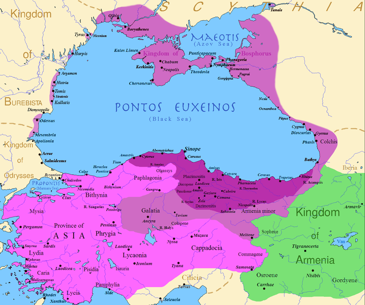
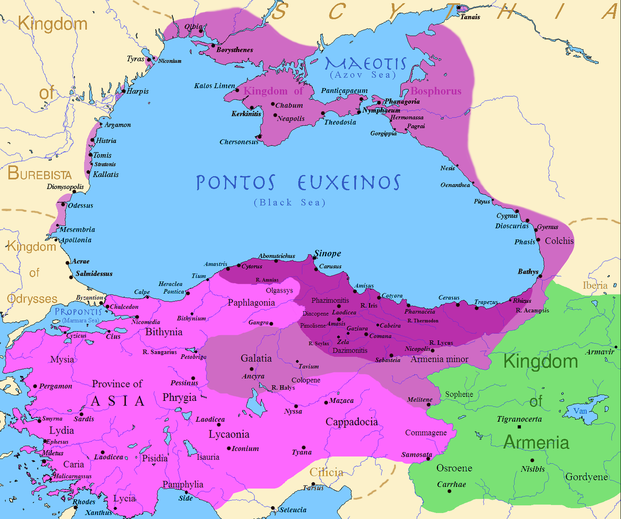
English: Map of the Kingdom of Pontus, Before the reign of Mithridates VI (darkest purple), after his conquests (purple), and his conquests in the first Mithridatic wars (pink); little adds (ancient shorelines & some greek colonies under Mithridate's rule) according with V. Yanko-Hombach, A.S. Gilbert, N. Panin, P. M. Dolukhanov: The Black Sea Flood Question: Changes in Coastline, Climate, and Human Settlement, Springer, Netherlands, 2007, and with Appianus, Plutarchus & Strabo. |
| თარიღი | |
| წყარო | I (Javierfv1212 (talk)) created this work entirely by myself. Sources, Cambridge Ancient history volume 9, Penguin atlas of Greek history and the Foreign Policy of Mithridates VI Eupator. |
| ავტორი | Javierfv1212 (talk) |
ლიცენზია
| ეს ნამუშევარი მისი ავტორის Javierfv1212 at ინგლისური ვიკიპედია მიერ გადაცემულია საზოგადოებრივ დომენში. ეს მოქმედებს მთელი მსოფლიოს მასშტაბით. ზოგიერთ ქვეყანაში ეს შეიძლება იურიდიულად შეუძლებელი იყოს, ასეთ შემთხვევაში: Javierfv1212 უფლება მისცა ნებისმიერს, რათა გამოიყენონ ეს ნამუშევარი ნებისმიერი მიზნით, ყოველგვარი წინაპირობის გარეშე, თუ რაიმე პირობა კანონის მიერ არ არის მოთხოვნილი. |
ატვირთვის ჟურნალი
Transferred from en.wikipedia to Commons by Falcorian using CommonsHelper.
The original description page was here. All following user names refer to en.wikipedia.
- 2009-07-19 23:42 Javierfv1212 1551×1296× (205182 bytes) {{Information |Description = Map of the Kingdom of Pontus, Before the reign of mithridates VI (darkest purple), after his conquests (purple), and his conquests in the first Mithridatic wars (pink). |Source = I (~~~) created this work entirel
ფაილის ისტორია
დააწკაპუნეთ თარიღზე/დროზე ფაილის დასათვალიერებლად, როგორც ის მაშინ გამოიყურებოდა.
| თარიღი/დრო | მინიატიურა | ზომები | მომხმარებელი | შენიშვნა | |
|---|---|---|---|---|---|
| მიმდინარე | 02:00, 9 დეკემბერი 2017 | | 1 551×1 296 (265 კბ) | SteinsplitterBot | Bot: Image rotated by 90° |
| 00:00, 9 დეკემბერი 2017 |  | 1 296×1 551 (316 კბ) | SteinsplitterBot | Bot: Image rotated by 270° | |
| 17:54, 22 სექტემბერი 2016 |  | 1 551×1 296 (265 კბ) | Hohum | Lighten water area | |
| 11:21, 9 აგვისტო 2016 |  | 1 551×1 296 (260 კბ) | MAXHO | Details : more cities & shoreline of this time | |
| 20:57, 1 ოქტომბერი 2015 |  | 1 551×1 296 (249 კბ) | Spiridon Ion Cepleanu | Cosmetic again | |
| 12:55, 30 სექტემბერი 2015 |  | 1 551×1 296 (247 კბ) | Spiridon Ion Cepleanu | Cosmetic colours & background names | |
| 14:21, 7 აპრილი 2014 |  | 1 551×1 296 (225 კბ) | Spiridon Ion Cepleanu | Little changes (ancient shoreline & some greek colonies under Pontic rule) according with V. Yanko-Hombach, A.S. Gilbert, N. Panin, P. M. Dolukhanov: ''The Black Sea Flood Question: Changes in Coastline, Climate, and Human Settlement'', Springer, Nethe... | |
| 04:14, 20 ივლისი 2009 |  | 1 551×1 296 (200 კბ) | File Upload Bot (Magnus Manske) | {{BotMoveToCommons|en.wikipedia|year={{subst:CURRENTYEAR}}|month={{subst:CURRENTMONTHNAME}}|day={{subst:CURRENTDAY}}}} {{Information |Description={{en|Map of the Kingdom of Pontus, Before the reign of mithridates VI (darkest purple), after his conquests |
ბმულები
ამ ფაილზე ბმული მოცემულია შემდეგ გვერდებზე:
ფაილის გლობალური გამოყენება
ეს ფაილი გამოიყენება შემდეგ ვიკებში:
- გამოყენება ar.wikipedia.org-ში
- გამოყენება ast.wikipedia.org-ში
- გამოყენება azb.wikipedia.org-ში
- გამოყენება az.wikipedia.org-ში
- გამოყენება bg.wikipedia.org-ში
- გამოყენება br.wikipedia.org-ში
- გამოყენება ca.wikipedia.org-ში
- გამოყენება cs.wikipedia.org-ში
- გამოყენება da.wikipedia.org-ში
- გამოყენება de.wikipedia.org-ში
- გამოყენება el.wikipedia.org-ში
- გამოყენება en.wikipedia.org-ში
- გამოყენება es.wikipedia.org-ში
- გამოყენება et.wikipedia.org-ში
- გამოყენება eu.wikipedia.org-ში
- გამოყენება fa.wikipedia.org-ში
- გამოყენება fr.wikipedia.org-ში
იხილეთ, ამ ფაილის გლობალური გამოყენება.