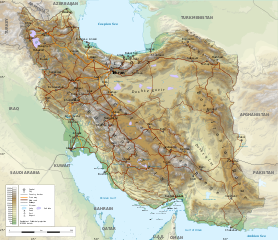
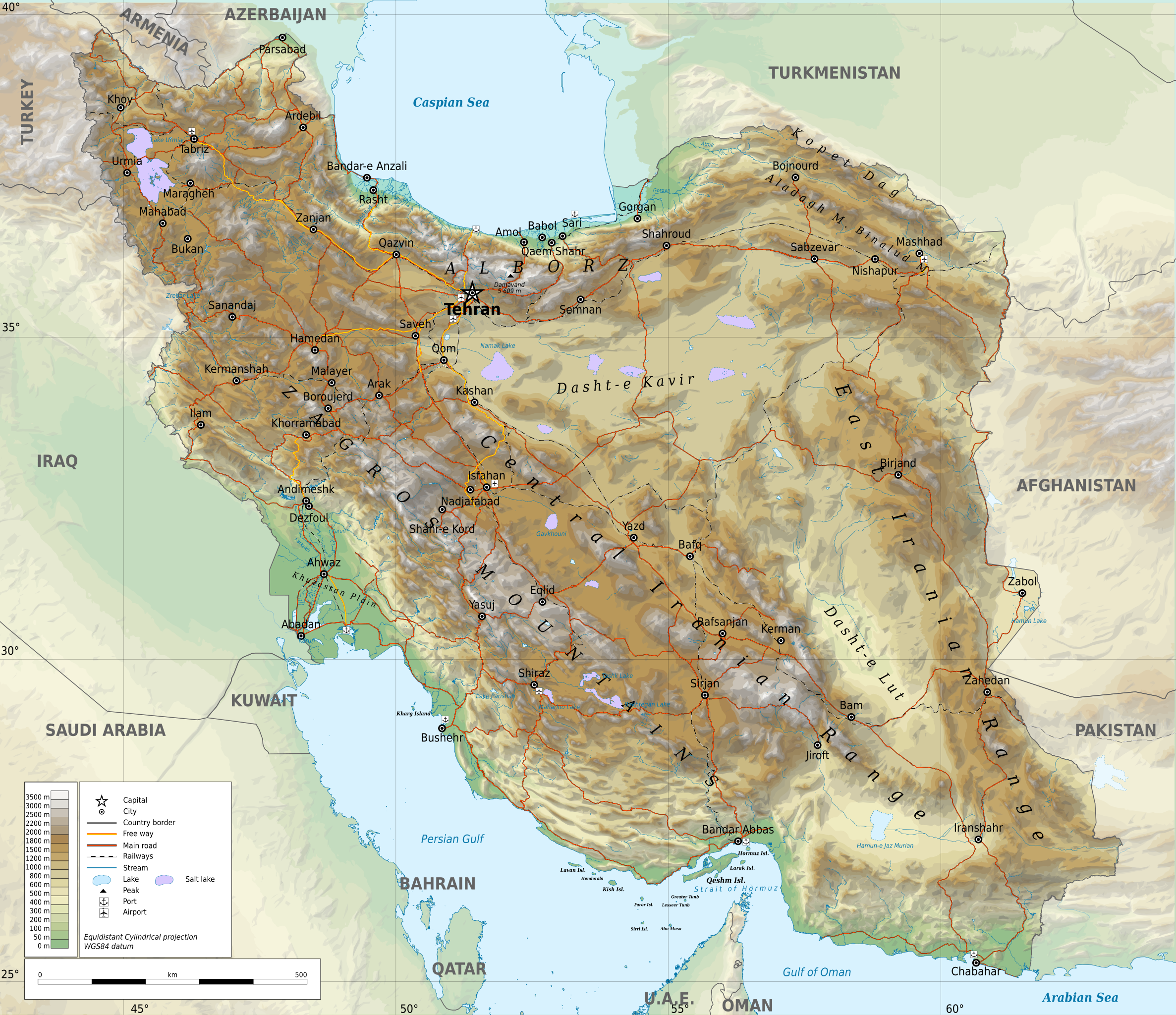
ფაილი:Iran-geographic map.svg

თავდაპირველი ფაილი (ფაილი SVG, ნომინალურად 3 013 × 2 600 პიქსელი, ფაილის ზომა: 12,7 მბ)
| ეს ფაილი მდებარეობს Wikimedia Commons სერვერზე. იხილეთ მისი აღწერის გვერდი სრული ინფორმაციისთვის. |
 |
გადასვლა ფაილის გვერდზე |
რეზიუმე
| აღწერა |
English: Geographic map of Iran. Limits of the map:
|
| თარიღი | |
| წყარო |
პირადი ნამუშევარი
|
| ავტორი | Ikonact |
| უფლება (ფაილის მეორეული გამოყენება) |
Any use of this map is subject of the license(s) stated below with the condition that you credit (Wikimedia Commons user: Ikonact) as the author . A message with a reply address would also be greatly appreciated. |
| SVG genesis | ამ SVG ფაილის კოდი კორექტულია. |
ლიცენზია
| This work contains information from OpenStreetMap, which is made available under the Open Database License (ODbL).
The ODbL does not require any particular license for maps produced from ODbL data. Prior to 1 August 2020, map tiles produced by the OpenStreetMap Foundation were licensed under the CC-BY-SA-2.0 license. Maps produced by other people may be subject to other licences. |
- თქვენ თავისუფლად შეგიძლიათ:
- ნამუშევრის გაზიარება – ნამუშევრის კოპირება, გავრცელება და გადაცემა.
- შექმნათ დაფუძნებულები – ნამუშევრის შესწორება
- შემდეგი პირობებით:
- მოხსენიება – თქვენ უნდა მიუთითოთ წყაროს შემქმნელი იმ გზით, რომელიც დანიშნა ავტორმა ან საავტორო უფლებების მფლობელმა. მაგრამ არა ისე, თითქოს წყაროს ავტორი მხარს გიჭერთ თქვენ ან დაუჭირა თქვენს მიერ შექმნილ ნაწარმოებს.
- გავრცელება იგივე პირობებეით – თუ თქვენ ცვლით, ან ქმნით ახალ ნაშრომს ამ ნამუშევრის გამოყენებთ, თქვენ გაქვთ უფლება გაავრცელოთ იგი იგივე ან შესაბამისი ლიცენზიით, რომლითაც ვრცელდება წყარო.
Assessment
|
ფაილის ისტორია
დააწკაპუნეთ თარიღზე/დროზე ფაილის დასათვალიერებლად, როგორც ის მაშინ გამოიყურებოდა.
| თარიღი/დრო | მინიატიურა | ზომები | მომხმარებელი | შენიშვნა | |
|---|---|---|---|---|---|
| მიმდინარე | 21:45, 20 სექტემბერი 2023 | | 3 013×2 600 (12,7 მბ) | Socialdilema | File uploaded using svgtranslate tool (https://svgtranslate.toolforge.org/). Added translation for ca. |
| 17:25, 20 სექტემბერი 2023 |  | 3 013×2 600 (12,69 მბ) | Socialdilema | File uploaded using svgtranslate tool (https://svgtranslate.toolforge.org/). Added translation for ca. | |
| 17:22, 20 სექტემბერი 2023 |  | 3 013×2 600 (12,68 მბ) | Socialdilema | File uploaded using svgtranslate tool (https://svgtranslate.toolforge.org/). Added translation for ca. | |
| 14:08, 8 მაისი 2020 |  | 3 013×2 600 (12,62 მბ) | Yamaha5 | File uploaded using svgtranslate tool (https://tools.wmflabs.org/svgtranslate/). Added translation for fa. | |
| 20:44, 1 მაისი 2020 |  | 3 013×2 600 (12,62 მბ) | Ikonact | + hidden Text: MW workaround for displaying translations | |
| 20:43, 1 მაისი 2020 |  | 3 013×2 600 (12,62 მბ) | Ikonact | + hidden Text: MW workaround for displaying translations | |
| 20:39, 1 მაისი 2020 |  | 3 013×2 600 (12,62 მბ) | Ikonact | File uploaded using svgtranslate tool (https://tools.wmflabs.org/svgtranslate/). Added translation for bg. | |
| 20:01, 1 მაისი 2020 |  | 3 013×2 600 (12,55 მბ) | Ikonact | + hidden Text: MW workaround for displaying translations | |
| 21:49, 30 აპრილი 2020 |  | 3 013×2 600 (12,55 მბ) | Ahmad252 | File uploaded using svgtranslate tool (https://tools.wmflabs.org/svgtranslate/). Added translation for fa. | |
| 21:10, 30 აპრილი 2020 |  | 3 013×2 600 (13,24 მბ) | Ikonact | + legend |
ბმულები
ამ ფაილზე ბმული მოცემულია შემდეგ გვერდებზე:
ფაილის გლობალური გამოყენება
ეს ფაილი გამოიყენება შემდეგ ვიკებში:
- გამოყენება ar.wikipedia.org-ში
- გამოყენება ast.wikipedia.org-ში
- გამოყენება avk.wikipedia.org-ში
- გამოყენება az.wikipedia.org-ში
- გამოყენება bg.wikipedia.org-ში
- გამოყენება bn.wikipedia.org-ში
- გამოყენება ca.wikipedia.org-ში
- გამოყენება ckb.wikipedia.org-ში
- გამოყენება cs.wikipedia.org-ში
- გამოყენება da.wikipedia.org-ში
- გამოყენება diq.wikipedia.org-ში
- გამოყენება el.wikipedia.org-ში
- გამოყენება en.wikipedia.org-ში
- გამოყენება eo.wikipedia.org-ში
- გამოყენება eu.wikipedia.org-ში
- გამოყენება fa.wikipedia.org-ში
- جغرافیای ایران
- کاربر:Alieseraj
- توپوگرافی
- کاربر:مام وطن
- کاربر:Basp1
- کاربر:جعبه کاربر/مدافع خاک ایران
- کاربر:Gshahali
- بحث کاربر:Zzvf
- کاربر:Hamid Hassani
- کاربر:Derakhshan
- کاربر:Wiki center
- ویکیپدیا:گزیدن نگاره برگزیده/مه-۲۰۲۰
- کاربر:Arian.ramin
- ویکیپدیا:قهوهخانه/فنی/بایگانی ۶۵
- ویکیپدیا:گزیدن نگاره برگزیده/Iran-geographic map.svg
- کاربر:Adel2020
- ویکیپدیا:نگاره روز/اوت ۲۰۲۲
- کاربر:Amdanesh
- کاربر:Adolfzl64
იხილეთ, ამ ფაილის გლობალური გამოყენება.