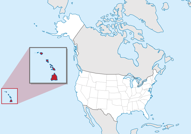
ფაილი:Hawaii in United States (zoom) (US50) (-grid).svg

ამ SVG ფაილის PNG წინასწარი გადახედვის ზომაა: 800 × 561 პიქსელი. სხვა გაფართოება: 320 × 224 პიქსელი | 640 × 449 პიქსელი | 1 024 × 718 პიქსელი | 1 280 × 897 პიქსელი | 2 560 × 1 795 პიქსელი | 2 078 × 1 457 პიქსელი.
თავდაპირველი ფაილი (ფაილი SVG, ნომინალურად 2 078 × 1 457 პიქსელი, ფაილის ზომა: 256 კბ)
| ეს ფაილი მდებარეობს Wikimedia Commons სერვერზე. იხილეთ მისი აღწერის გვერდი სრული ინფორმაციისთვის. |
_(US50)_(-grid).svg?uselang=ka) |
გადასვლა ფაილის გვერდზე |
რეზიუმე
.svg)
.svg)
.svg)
.svg)
.svg)
.svg)
.svg)

-en.svg)

.svg)
.svg)
.svg)

_(US48).svg)
_(small_islands_magnified)_(-mini_map_-rivers).svg)
.svg)
_(extra_close)_(US48).svg)
.svg)
_(zoom).svg)

.svg)


_(UNMIK).svg)
.svg)
_(disputed_hatched).svg)
_(claimed_and_disputed_hatched).svg)
.svg)
.svg)
_(%2Ball_claims_hatched).svg)

.svg)
_(shade).svg)
_(shade)_(special_marker).svg)
_(-mini_map).svg)
_(-mini_map).svg)
_(-mini_map).svg)


.svg)

.svg)
_(US50)_(-grid).svg)
ლიცენზია
This image is in the public domain in the United States because it only contains materials that originally came from the United States Geological Survey, an agency of the United States Department of the Interior. For more information, see the official USGS copyright policy.
|

|
I'd greatly appreciate, that you attribute this media file to Wikimedia Commons, if used outside Wikipedia or Commons. For use in publications such as books, newspapers, blogs, websites, please insert here the following line:
|
_(US50)_(-grid).svg&action=edit&redlink=1)
ფაილის ისტორია
დააწკაპუნეთ თარიღზე/დროზე ფაილის დასათვალიერებლად, როგორც ის მაშინ გამოიყურებოდა.
| თარიღი/დრო | მინიატიურა | ზომები | მომხმარებელი | შენიშვნა | |
|---|---|---|---|---|---|
| მიმდინარე | 18:11, 20 მარტი 2012 | | 2 078×1 457 (256 კბ) | TUBS | corr alabama colors |
| 21:00, 30 ივლისი 2011 |  | 2 078×1 457 (395 კბ) | TUBS | == {{int:filedesc}} == {{Information |Description={{de|Lage von XY (siehe Dateiname) in den Vereinigten Staaten.}} {{en|Location of state of XY (see filename) in the United States}} |Source={{own}}{{Adobe |
ბმულები
ამ ფაილზე ბმული მოცემულია შემდეგ გვერდებზე:
ფაილის გლობალური გამოყენება
ეს ფაილი გამოიყენება შემდეგ ვიკებში:
- გამოყენება az.wiktionary.org-ში
- გამოყენება bg.wikipedia.org-ში
- გამოყენება bh.wikipedia.org-ში
- გამოყენება bs.wikipedia.org-ში
- გამოყენება bxr.wikipedia.org-ში
- გამოყენება ca.wikipedia.org-ში
- გამოყენება cdo.wikipedia.org-ში
- გამოყენება ceb.wikipedia.org-ში
- გამოყენება ce.wikipedia.org-ში
- გამოყენება chr.wikipedia.org-ში
- გამოყენება cs.wikipedia.org-ში
- გამოყენება da.wikipedia.org-ში
- გამოყენება de.wikipedia.org-ში
- გამოყენება eml.wikipedia.org-ში
- გამოყენება en.wikipedia.org-ში
- List of people from Hawaii
- List of Hawaii state symbols
- List of active separatist movements in Oceania
- Wikipedia talk:Graphics Lab/Illustration workshop/Archive 3
- Callistosporium vinosobrunneum
- Marasmiellus hapuuarum
- Marasmius koae
- Mycena marasmielloides
- Pleurocybella ohiae
- Environmental issues in Hawaii
- Paleontology in Hawaii
- Wikipedia talk:WikiProject Maps/Archive 2013
- Wikipedia talk:Graphics Lab/Archive 4
- Wikipedia:Graphics Lab/Map workshop/Archive/Dec 2015
- File talk:Hawaii in United States (zoom) (US50) (-grid).svg
- გამოყენება en.wikinews.org-ში
- გამოყენება en.wiktionary.org-ში
- გამოყენება eo.wikipedia.org-ში
- გამოყენება fa.wikipedia.org-ში
- გამოყენება fi.wikipedia.org-ში
- გამოყენება fi.wikiquote.org-ში
- გამოყენება fr.wikipedia.org-ში
_(US50)_(-grid).svg)
იხილეთ, ამ ფაილის გლობალური გამოყენება.
_(US50)_(-grid).svg)
_(US50)_(-grid).svg)