ფაილი:French Polynesia relief map with communes.svg

თავდაპირველი ფაილი (ფაილი SVG, ნომინალურად 1 260 × 1 260 პიქსელი, ფაილის ზომა: 1,52 მბ)
| ეს ფაილი მდებარეობს Wikimedia Commons სერვერზე. იხილეთ მისი აღწერის გვერდი სრული ინფორმაციისთვის. |
 |
გადასვლა ფაილის გვერდზე |
რეზიუმე
| აღწერა |
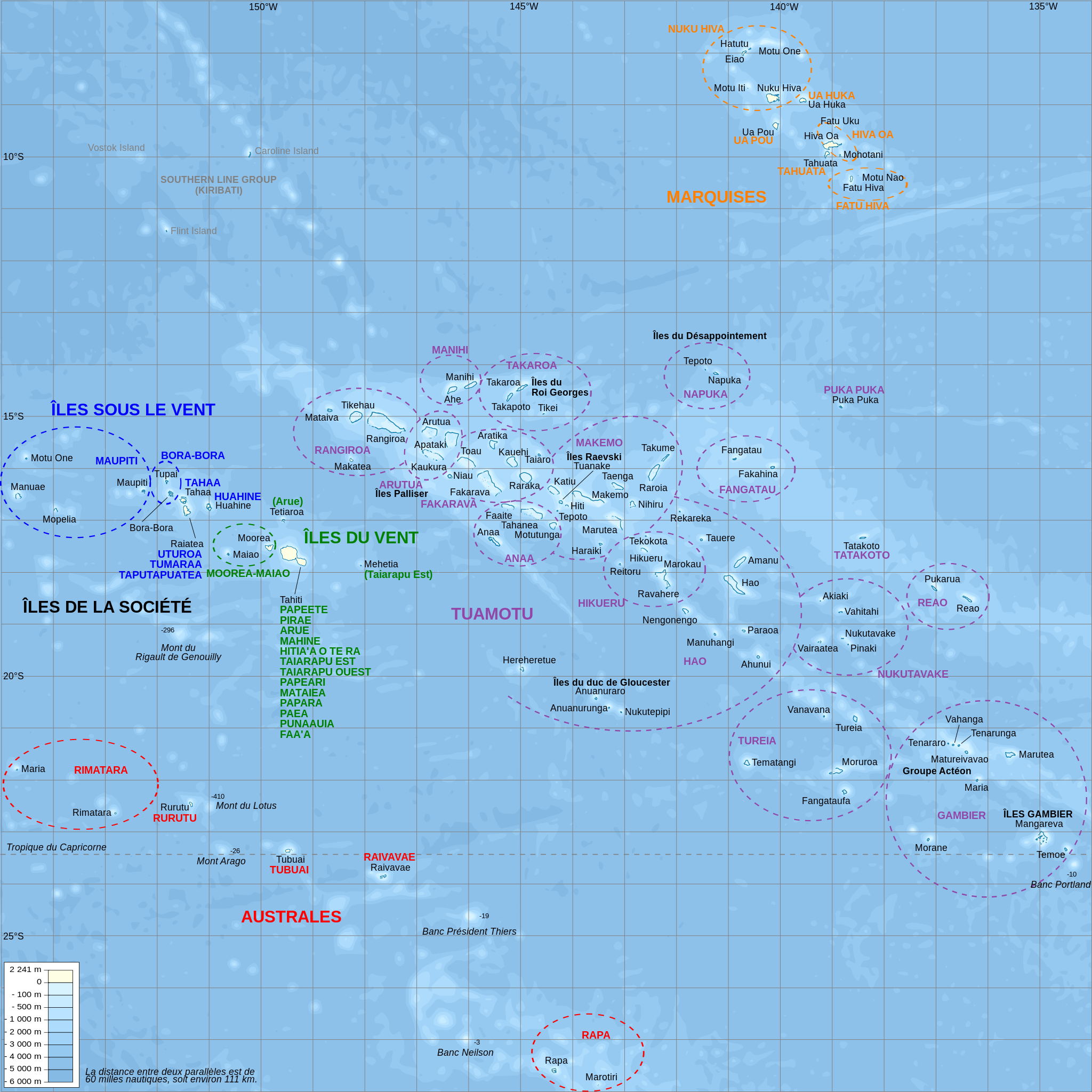
Català: Mapa topogràfic amb noms de subdivisions de la Polinèsia Francesa (en francès)
English: Topographic map with subdivision names of French Polynesia (in French)
Français : Carte topographique de la Polynésie française, en français, avec les noms des subdivisions (communes et archipels) |
| თარიღი | |
| წყარო |
Own work.
Data sources :
Softwares used :
Others :
|
| ავტორი | L. Claudel (Sardon - fr:Sardon) |
| სხვა ვერსიები |
Other related versions: []
|


|
ეს SVG ფაილი იყენებს თანდართულ ტექსტს, რომელიც ადვილად შეიძლება ითარგმნოს თქვენს ენაზე using [toolforge:svgtranslate/File:French_Polynesia_relief_map_with_communes.svglink this automated tool]. გაიგეთ მეტი. You can also download it and translate it manually using a text editor. |
This file is translated using SVG For most Wikipedia projects, you can embed the file normally (without a To translate the text into your language, you can use the SVG Translate tool. Alternatively, you can download the file to your computer, add your translations using whatever software you're familiar with, and re-upload it with the same name. You will find help in Graphics Lab if you're not sure how to do this. |
ლიცენზია

|
თქვენ შეგიძიათ გაავრცელოთ ან შეცვალოთ დოკუმენტი GNU Free Documentation ლიცენზიის 1.2 ან უფრო გვიანდელი ვერსიის პირობების თანახმად, რომელიც გამოქვეყნებულია თავისუფალი პროგრამული უზრუნველყოფის ფონდის მიერ, შეუცვლელი განყოფილებების გარეშე, პირველ და ბოლო გვერდებზე განთავსებულ ტექსტებზე. ლიცენზიის ასლი არის განთავსებული განყოფილებაში სახელად GNU Free Documentation License. |
- თქვენ თავისუფლად შეგიძლიათ:
- ნამუშევრის გაზიარება – ნამუშევრის კოპირება, გავრცელება და გადაცემა.
- შექმნათ დაფუძნებულები – ნამუშევრის შესწორება
- შემდეგი პირობებით:
- მოხსენიება – თქვენ უნდა მიუთითოთ წყაროს შემქმნელი იმ გზით, რომელიც დანიშნა ავტორმა ან საავტორო უფლებების მფლობელმა. მაგრამ არა ისე, თითქოს წყაროს ავტორი მხარს გიჭერთ თქვენ ან დაუჭირა თქვენს მიერ შექმნილ ნაწარმოებს.
- გავრცელება იგივე პირობებეით – თუ თქვენ ცვლით, ან ქმნით ახალ ნაშრომს ამ ნამუშევრის გამოყენებთ, თქვენ გაქვთ უფლება გაავრცელოთ იგი იგივე ან შესაბამისი ლიცენზიით, რომლითაც ვრცელდება წყარო.
ფაილის ისტორია
დააწკაპუნეთ თარიღზე/დროზე ფაილის დასათვალიერებლად, როგორც ის მაშინ გამოიყურებოდა.
| თარიღი/დრო | მინიატიურა | ზომები | მომხმარებელი | შენიშვნა | |
|---|---|---|---|---|---|
| მიმდინარე | 21:39, 15 თებერვალი 2024 | | 1 260×1 260 (1,52 მბ) | Manlleus | File uploaded using svgtranslate tool (https://svgtranslate.toolforge.org/). Added translation for ca. |
| 20:32, 16 ოქტომბერი 2008 |  | 1 260×1 260 (1,4 მბ) | Sardon | {{Information |Description={{en|1=Topographic map with subdivision names of French Polynesia (in French)}} {{fr|1=Carte topographique de la Polynésie française, en français, avec les noms des subdivisions (communes et archipels)}} |Source=Own work.{{cl |
ბმულები
ამ ფაილზე ბმული მოცემულია შემდეგ გვერდებზე:
ფაილის გლობალური გამოყენება
ეს ფაილი გამოიყენება შემდეგ ვიკებში:
- გამოყენება af.wikipedia.org-ში
- გამოყენება als.wikipedia.org-ში
- გამოყენება ar.wikipedia.org-ში
- გამოყენება ca.wikipedia.org-ში
- გამოყენება cs.wikipedia.org-ში
- გამოყენება de.wikipedia.org-ში
- გამოყენება de.wikivoyage.org-ში
- გამოყენება el.wikipedia.org-ში
- გამოყენება en.wikipedia.org-ში
- გამოყენება en.wiktionary.org-ში
- გამოყენება eo.wikipedia.org-ში
იხილეთ, ამ ფაილის გლობალური გამოყენება.