ფაილი:EB9 Aleutian Islands.jpg

ზომა წინასწარი გადახედვისას: 800 × 277 პიქსელი. სხვა გაფართოება: 320 × 111 პიქსელი | 640 × 221 პიქსელი | 1 619 × 560 პიქსელი.
თავდაპირველი ფაილი ((1 619 × 560 პიქსელი, ფაილის ზომა: 270 კბ, MIME ტიპი: image/jpeg))
| ეს ფაილი მდებარეობს Wikimedia Commons სერვერზე. იხილეთ მისი აღწერის გვერდი სრული ინფორმაციისთვის. |
 |
გადასვლა ფაილის გვერდზე |
რეზიუმე
| აღწერა |
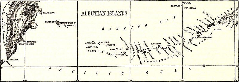
English: Map of the Aleutian Islands. |
|||
| თარიღი | ||||
| წყარო | Encyclopædia Britannica, 9th ed., Vol. I, p. 480. | |||
| ავტორი | Anonymous, but presumably engraved by either John Bartholomew & Son or William & Alexander Keith Johnston | |||
| უფლება (ფაილის მეორეული გამოყენება) |
|

ფაილის ისტორია
დააწკაპუნეთ თარიღზე/დროზე ფაილის დასათვალიერებლად, როგორც ის მაშინ გამოიყურებოდა.
| თარიღი/დრო | მინიატიურა | ზომები | მომხმარებელი | შენიშვნა | |
|---|---|---|---|---|---|
| მიმდინარე | 21:34, 18 იანვარი 2015 | 1 619×560 (270 კბ) | Library Guy | {{Information |Description ={{en|1=Map of the Aleutian Islands.}} |Source =''Encyclopædia Britannica'', Ninth Edition, v. 1, 1878, p. 480. |Author =Thomas Spencer Baynes and William Robertson Smith (eds.) |Date =published... |
ბმულები
ამ ფაილზე ბმული მოცემულია შემდეგ გვერდებზე:
ფაილის გლობალური გამოყენება
ეს ფაილი გამოიყენება შემდეგ ვიკებში:
- გამოყენება en.wikisource.org-ში