ფაილი:Cotabato province 1918 map.JPG
ზომა წინასწარი გადახედვისას: 369 × 599 პიქსელი. სხვა გაფართოება: 148 × 240 პიქსელი | 630 × 1 022 პიქსელი.
თავდაპირველი ფაილი ((630 × 1 022 პიქსელი, ფაილის ზომა: 218 კბ, MIME ტიპი: image/jpeg))
| ეს ფაილი მდებარეობს Wikimedia Commons სერვერზე. იხილეთ მისი აღწერის გვერდი სრული ინფორმაციისთვის. |
 |
გადასვლა ფაილის გვერდზე |
რეზიუმე
| აღწერა |
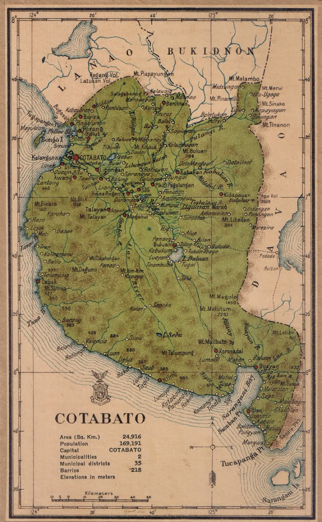
English: Map of Cotabato province in 1918 |
| თარიღი | |
| წყარო | Census of the Philippine Islands (1918) |
| ავტორი | Census Office of the Philippine Islands |
ლიცენზია
This media file is in the public domain in the United States. This applies to U.S. works where the copyright has expired, often because its first publication occurred prior to January 1, 1929, and if not then due to lack of notice or renewal. See this page for further explanation.
|
 | |
 |
This image might not be in the public domain outside of the United States; this especially applies in the countries and areas that do not apply the rule of the shorter term for US works, such as Canada, Mainland China (not Hong Kong or Macao), Germany, Mexico, and Switzerland. The creator and year of publication are essential information and must be provided. See Wikipedia:Public domain and Wikipedia:Copyrights for more details.
|
ფაილის ისტორია
დააწკაპუნეთ თარიღზე/დროზე ფაილის დასათვალიერებლად, როგორც ის მაშინ გამოიყურებოდა.
| თარიღი/დრო | მინიატიურა | ზომები | მომხმარებელი | შენიშვნა | |
|---|---|---|---|---|---|
| მიმდინარე | 04:13, 3 აგვისტო 2015 | | 630×1 022 (218 კბ) | Namayan | User created page with UploadWizard |
ბმულები
ამ ფაილზე ბმული მოცემულია შემდეგ გვერდებზე:
ფაილის გლობალური გამოყენება
ეს ფაილი გამოიყენება შემდეგ ვიკებში:
- გამოყენება en.wikipedia.org-ში