ფაილი:Afghanistan region during 500 BC.jpg
Afghanistan_region_during_500_BC.jpg ((348 × 347 პიქსელი, ფაილის ზომა: 56 კბ, MIME ტიპი: image/jpeg))
| ეს ფაილი მდებარეობს Wikimedia Commons სერვერზე. იხილეთ მისი აღწერის გვერდი სრული ინფორმაციისთვის. |
 |
გადასვლა ფაილის გვერდზე |
| აღწერა |
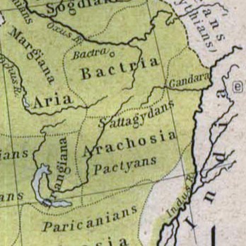
Español: Mapa histórico del Imperio Aqueménida.
English: Historic map of the Achaemenid Empire
Français : Carte historique de l'empire achéménide
Arachosia, Aria and Bactria were the ancient satraps of the Persian Achaemenid Empire that made up most of what is now Afghanistan and western Pakistan during 500 B.C. The main inhabitants of Arachosia were known as Pactyans, whose name possibly survives in today's Pakhtuns. |
||||
| თარიღი | |||||
| წყარო |
http://www.lib.utexas.edu/maps/historical/history_asia.html http://www.lib.utexas.edu/maps/historical/shepherd/persian_empire.jpg |
||||
| ავტორი | William R. Shepherd (b. 1871 - d. 1934) | ||||
| უფლება (ფაილის მეორეული გამოყენება) |
|
||||
| სხვა ვერსიები | File:Map of the Achaemenid Empire.jpg (full) | ||||
ფაილის ისტორია
დააწკაპუნეთ თარიღზე/დროზე ფაილის დასათვალიერებლად, როგორც ის მაშინ გამოიყურებოდა.
| თარიღი/დრო | მინიატიურა | ზომები | მომხმარებელი | შენიშვნა | |
|---|---|---|---|---|---|
| მიმდინარე | 13:48, 12 მარტი 2010 | | 348×347 (56 კბ) | Officer | {{Information |Description={{es|Mapa histórico del imperio Aqueménido.}} {{en|Historic map of the Achaemenid Empire}} {{fr|Carte historique de l'empire achéménide}} |Source=http://www.lib.utexas.edu/maps/historical/history_asia.html http://www.lib.ut |
| 20:47, 21 იანვარი 2010 |  | 324×357 (63 კბ) | Officer | {{Information |Description={{es|Mapa histórico del imperio Aqueménido.}} {{en|Historic map of the Achaemenid Empire}} {{fr|Carte historique de l'empire achéménide}} |Source=http://www.lib.utexas.edu/maps/historical/history_asia.html http://www.lib.ut |
ბმულები
ამ ფაილზე ბმული მოცემულია შემდეგ გვერდებზე:
ფაილის გლობალური გამოყენება
ეს ფაილი გამოიყენება შემდეგ ვიკებში:
- გამოყენება am.wikipedia.org-ში
- გამოყენება ar.wikipedia.org-ში
- გამოყენება azb.wikipedia.org-ში
- გამოყენება az.wikipedia.org-ში
- გამოყენება bg.wikipedia.org-ში
- გამოყენება bn.wikipedia.org-ში
- გამოყენება ca.wikipedia.org-ში
- გამოყენება de.wikipedia.org-ში
- გამოყენება en.wikipedia.org-ში
- გამოყენება eo.wikipedia.org-ში
- გამოყენება es.wikipedia.org-ში
- გამოყენება he.wikipedia.org-ში
- გამოყენება hi.wikipedia.org-ში
- გამოყენება hr.wikipedia.org-ში
- გამოყენება hy.wikipedia.org-ში
- გამოყენება id.wikipedia.org-ში
- გამოყენება it.wikipedia.org-ში
- გამოყენება ja.wikipedia.org-ში
- გამოყენება lt.wikipedia.org-ში
- გამოყენება mn.wikipedia.org-ში
- გამოყენება pt.wikipedia.org-ში
- გამოყენება ro.wikipedia.org-ში
- გამოყენება ru.wikipedia.org-ში
- გამოყენება sh.wikipedia.org-ში
- გამოყენება sk.wikipedia.org-ში
- გამოყენება sr.wikipedia.org-ში
- გამოყენება ta.wikipedia.org-ში
- გამოყენება tg.wikipedia.org-ში
- გამოყენება uk.wikipedia.org-ში
იხილეთ, ამ ფაილის გლობალური გამოყენება.