ფაილი:1730 Homann Map of Scandinavia, Norway, Sweden, Denmark, Finland and the Baltics - Geographicus - Scandinavia-homann-1730.jpg

ზომა წინასწარი გადახედვისას: 700 × 600 პიქსელი. სხვა გაფართოება: 280 × 240 პიქსელი | 560 × 480 პიქსელი | 896 × 768 პიქსელი | 1 195 × 1 024 პიქსელი | 2 390 × 2 048 პიქსელი | 5 000 × 4 285 პიქსელი.
თავდაპირველი ფაილი ((5 000 × 4 285 პიქსელი, ფაილის ზომა: 8,31 მბ, MIME ტიპი: image/jpeg))
| ეს ფაილი მდებარეობს Wikimedia Commons სერვერზე. იხილეთ მისი აღწერის გვერდი სრული ინფორმაციისთვის. |
 |
გადასვლა ფაილის გვერდზე |
|
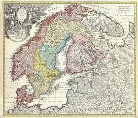
This image was selected as picture of the day on Wikimedia Commons for 1 December 2011. It was captioned as follows: English: Map of Scandinavia, the Baltic states, northernmost part of current Germany, and parts of Poland and Russia, by Johann Baptist Homann, about 1730. Other languages:
Dansk: Kort over Skandinavien, Baltikum, det nordlige af nutidens Tyskland samt dele af Polen og Rusland. Kortet er udformet af Johann Baptist Homann omkring 1730. English: Map of Scandinavia, the Baltic states, northernmost part of current Germany, and parts of Poland and Russia, by Johann Baptist Homann, about 1730. Español: Mapa de Escandinavia, los países bálticos, el norte de la actual Alemania y partes de Polonia y Rusia, por Johann Baptist Homann (circa 1730). Français : Carte de la Scandinavie et de la Baltique de 1730. Par le traité de Nystad en 1721, la Suède a cédé l'Estonie, la Livonie, l'Ingrie et une grande partie de la Carélie à la Russie. Italiano: Mappa della Scandinavia, gli Stati baltici, la parte settentrionale della Germania e parte di Polonia e Russia di Johann Baptist Homann, circa 1730. Magyar: Johann Baptist Homann 1730 körül megjelent Skandinávia-térképe, amely ábrázolja a mai balti államokat, valamint Németország, Lengyelország és Oroszország egyes részeit is. Nederlands: Kaart van Scandinavië, Finland het Oostzeegebied en het noordwesten van Rusland door Johann Baptist Homann (rond 1730). Português: Mapa da Escandinávia, estados Bálticos, partes ao norte da atual Alemanha, Polônia e Rússia, por Johann Baptist Homann. Українська: Чудова докладна мапа Скандинавії, країн Балтії, північної частини сучасної Німеччини, частини Речі Посполитої і Росії роботи німецького картографа Йоганна-Баптиста Гоманна, надрукована в Нюрнберзі приблизно 1730 р., гравіювання було зроблене приблизно 1715 р. ქართული: სკანდინავიის, ბალტიის ქვეყნების, დღევანდელი გერმანიის ჩრდილოეთი ნაწილის, პოლონეთისა და რუსეთის ნაწილების რუკა, იოჰან ბაპტისტ ჰომანის მიხედვით, დაახლოებით 1730 წელი. 日本語: ヨハン・バプティスト・ホマンによるスカンジナビア半島、バルト諸国、現在のドイツの最北部、及びポーランドとロシアの各一部の地図。1730年頃。 |
| სათაური |
Scandinavia complectens Sueciae Daniae & Norvegiae Regna ex Tabulis Joh. Bapt Homanni Norimbergae. |
|||||||||||||||||||||||
| Description |
العربية: خريطة لسكندنافيا موضحة الدنمارك والنرويج والسويد وفنلندا والدول البلطية
English: A detailed c. 1730 J. B. Homann map of Scandinavia. Depicts both Denmark, Norway, Sweden, Finland and the Baltic states of Livonia, Latvia and Curlandia. The map notes fortified cities, villages, roads, bridges, forests, castles and topography. The elaborate title cartouche in the upper left quadrant features angels supporting a title curtain and a medallion supporting an alternative title in French, Les Trois Covronnes du Nord . Printed in Nuremburg. This map must have been engraved before 1715 when Homann was appointed Geographer to the King. The map does not have the cum privilegio (with privilege; i.e. copyright authority given by the Emperor) as part of the title, however it was included in the c. 1750 Homann Heirs Maior Atlas Scholasticus ex Triginta Sex Generalibus et Specialibus…. as well as in Homann’s Grosser Atlas .
Français : Carte de la Scandinavie et de la Baltique de 1730. Par le traité de Nystad en 1721, la Suède a cédé l'Estonie, la Livonie, l'Ingrie et une grande partie de la Carélie à la Russie. |
|||||||||||||||||||||||
| თარიღი | circa 1730(undated) | |||||||||||||||||||||||
| წყარო |
Major Atlas Scholasticus Ex Triginta sex Generalibus et Specialibus Mappis Homannianis..., c. 1750. / Also issued in Homann's Grosser Atlas
|
|||||||||||||||||||||||
| შემქმნელი |
|
|||||||||||||||||||||||
| უფლება (ფაილის მეორეული გამოყენება) |
|
|||||||||||||||||||||||
| Georeferencing | If inappropriate please set warp_status = skip to hide. | |||||||||||||||||||||||
| Archival data | ||||||||||||||||||||||||
| საინვენტარო ნომერი |
Geographicus link: Scandinavia-homann-1730 |
|||||||||||||||||||||||
| ზომები | სიმაღლე: 19 in (48,2 cm); სიგანე: 22 in (55,8 cm) | |||||||||||||||||||||||
.jpg)
ფაილის ისტორია
დააწკაპუნეთ თარიღზე/დროზე ფაილის დასათვალიერებლად, როგორც ის მაშინ გამოიყურებოდა.
| თარიღი/დრო | მინიატიურა | ზომები | მომხმარებელი | შენიშვნა | |
|---|---|---|---|---|---|
| მიმდინარე | 21:50, 16 მარტი 2011 | | 5 000×4 285 (8,31 მბ) | BotMultichill | {{subst:User:Multichill/Geographicus |link=http://www.geographicus.com/P/AntiqueMap/Scandinavia-homann-1730 |product_name=1730 Homann Map of Scandinavia: Norway, Sweden, Denmark, Finland and the Baltics |map_title=Scandinavia complectens Sueciae Daniae & |
ბმულები
ამ ფაილზე ბმული მოცემულია შემდეგ გვერდებზე:
ფაილის გლობალური გამოყენება
ეს ფაილი გამოიყენება შემდეგ ვიკებში:
- გამოყენება ast.wikipedia.org-ში
- გამოყენება az.wikipedia.org-ში
- გამოყენება be-tarask.wikipedia.org-ში
- გამოყენება bn.wikipedia.org-ში
- გამოყენება ca.wikipedia.org-ში
- გამოყენება ckb.wikipedia.org-ში
- გამოყენება crh.wikipedia.org-ში
- გამოყენება cs.wikipedia.org-ში
- გამოყენება cv.wikipedia.org-ში
- გამოყენება de.wikipedia.org-ში
- გამოყენება el.wikipedia.org-ში
- გამოყენება en.wikipedia.org-ში
- History of Finland
- Johann Homann
- Talk:Johann Homann
- History of Sweden
- History of Denmark
- History of Norway
- Portal:Sweden
- History of Scandinavia
- Portal:Finland
- Portal:Norway
- Wikipedia:Featured pictures/Diagrams, drawings, and maps/Maps
- Expedition to Lapland
- Wikipedia:Featured pictures thumbs/42
- Wikipedia:Featured picture candidates/July-2014
- Wikipedia:Featured picture candidates/Naked men and misleading nomination names.
- User talk:Adam Cuerden/Archive 4
- Wikipedia:Picture of the day/April 2015
- Template:POTD/2015-04-30
- Wikipedia:Main Page history/2015 April 30
- User talk:Adam Cuerden/Archive 5
- Portal:Geography/Selected picture
- გამოყენება en.wikiversity.org-ში
- გამოყენება es.wikipedia.org-ში
- გამოყენება et.wikipedia.org-ში
- გამოყენება eu.wikipedia.org-ში
- გამოყენება fa.wikipedia.org-ში
იხილეთ, ამ ფაილის გლობალური გამოყენება.