ფაილი:Routes of the Spanish Armada.gif

ზომა წინასწარი გადახედვისას: 329 × 599 პიქსელი. სხვა გაფართოება: 132 × 240 პიქსელი | 415 × 756 პიქსელი.
თავდაპირველი ფაილი ((415 × 756 პიქსელი, ფაილის ზომა: 27 კბ, MIME ტიპი: image/gif))
| ეს ფაილი მდებარეობს Wikimedia Commons სერვერზე. იხილეთ მისი აღწერის გვერდი სრული ინფორმაციისთვის. |
 |
გადასვლა ფაილის გვერდზე |
რეზიუმე
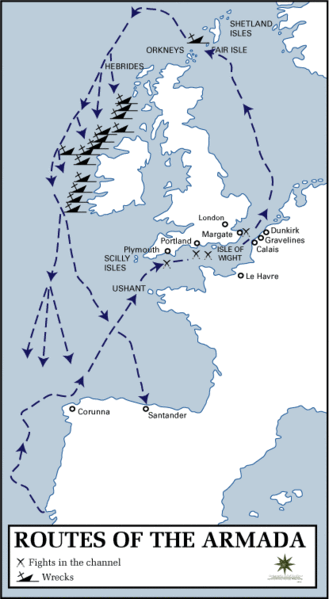
Map of the route taken by the Spanish Armada.
Source: History Department of the United States Military Academy at West Point
Other version: Classical Chinese translation, German translation, Spanish translation, French translation
.svg)
derivative works
Derivative works of this file: Routes of the Spanish Armada-es.svg
ლიცენზია
This work is in the public domain in the United States because it is a work prepared by an officer or employee of the United States Government as part of that person’s official duties under the terms of Title 17, Chapter 1, Section 105 of the US Code.
Note: This only applies to original works of the Federal Government and not to the work of any individual U.S. state, territory, commonwealth, county, municipality, or any other subdivision. This template also does not apply to postage stamp designs published by the United States Postal Service since 1978. (See § 313.6(C)(1) of Compendium of U.S. Copyright Office Practices). It also does not apply to certain US coins; see The US Mint Terms of Use.
|
 | |
| This file has been identified as being free of known restrictions under copyright law, including all related and neighboring rights. | ||
ფაილის ისტორია
დააწკაპუნეთ თარიღზე/დროზე ფაილის დასათვალიერებლად, როგორც ის მაშინ გამოიყურებოდა.
| თარიღი/დრო | მინიატიურა | ზომები | მომხმარებელი | შენიშვნა | |
|---|---|---|---|---|---|
| მიმდინარე | 14:23, 18 იანვარი 2006 | | 415×756 (27 კბ) | Kooma | ==Summary== Map of the route taken by the Spanish Armada. Source: [http://www.dean.usma.edu/history/atlases/dawn_modern_warfare/routes_armada.html History Department of the United States Military Academy at West Point] ==Licensing== {{PD-USGov}} [[ |
ბმულები
ამ ფაილზე ბმული მოცემულია შემდეგ გვერდებზე:
ფაილის გლობალური გამოყენება
ეს ფაილი გამოიყენება შემდეგ ვიკებში:
- გამოყენება af.wikipedia.org-ში
- გამოყენება azb.wikipedia.org-ში
- გამოყენება az.wikipedia.org-ში
- გამოყენება be.wikipedia.org-ში
- გამოყენება da.wikipedia.org-ში
- გამოყენება da.wikibooks.org-ში
- გამოყენება el.wikipedia.org-ში
- გამოყენება en.wikipedia.org-ში
- გამოყენება et.wikipedia.org-ში
- გამოყენება fa.wikipedia.org-ში
- გამოყენება fi.wikipedia.org-ში
- გამოყენება fr.wikipedia.org-ში
- გამოყენება ga.wikipedia.org-ში
- გამოყენება hu.wikipedia.org-ში
- გამოყენება hy.wikipedia.org-ში
- გამოყენება it.wikipedia.org-ში
- გამოყენება ja.wikipedia.org-ში
- გამოყენება lv.wikipedia.org-ში
- გამოყენება nl.wikipedia.org-ში
- გამოყენება no.wikipedia.org-ში
- გამოყენება pl.wikipedia.org-ში
- გამოყენება pt.wikipedia.org-ში
- გამოყენება ro.wikipedia.org-ში
- გამოყენება simple.wikipedia.org-ში
- გამოყენება sv.wikipedia.org-ში
- გამოყენება ta.wikipedia.org-ში
- გამოყენება uk.wikipedia.org-ში
- გამოყენება www.wikidata.org-ში