ფაილი:Henrietta Island, Russia.jpg

ზომა წინასწარი გადახედვისას: 600 × 600 პიქსელი. სხვა გაფართოება: 240 × 240 პიქსელი | 480 × 480 პიქსელი | 768 × 768 პიქსელი | 1 024 × 1 024 პიქსელი | 2 000 × 2 000 პიქსელი.
თავდაპირველი ფაილი ((2 000 × 2 000 პიქსელი, ფაილის ზომა: 2,22 მბ, MIME ტიპი: image/jpeg))
| ეს ფაილი მდებარეობს Wikimedia Commons სერვერზე. იხილეთ მისი აღწერის გვერდი სრული ინფორმაციისთვის. |
 |
გადასვლა ფაილის გვერდზე |
რეზიუმე
| აღწერა |
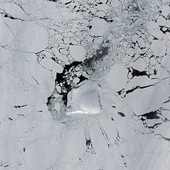
English: The Advanced Land Imager (ALI) on NASA’s Earth Observing-1 satellite captured this image of Henrietta Island. In this natural-color image, the island casts shadows to the north, thanks to the Sun’s low angle and the island’s own steep, rugged coastline. Inland, an icy dome covers most of the island, its southern surface slightly illuminated. |
| თარიღი | |
| წყარო | NASA Earth Observatory |
| ავტორი | Jesse Allen |
Instrument: EO-1 - ALI
ლიცენზია
| This file is in the public domain in the United States because it was solely created by NASA. NASA copyright policy states that "NASA material is not protected by copyright unless noted". (See Template:PD-USGov, NASA copyright policy page or JPL Image Use Policy.) | ||
 |
Warnings:
|
| Annotations | This image is annotated: View the annotations at Commons |
ფაილის ისტორია
დააწკაპუნეთ თარიღზე/დროზე ფაილის დასათვალიერებლად, როგორც ის მაშინ გამოიყურებოდა.
| თარიღი/დრო | მინიატიურა | ზომები | მომხმარებელი | შენიშვნა | |
|---|---|---|---|---|---|
| მიმდინარე | 11:23, 23 მაისი 2009 | | 2 000×2 000 (2,22 მბ) | Originalwana | {{Information |Description={{en|1=The Advanced Land Imager (ALI) on NASA’s Earth Observing-1 satellite captured this image of Henrietta Island. In this natural-color image, the island casts shadows to the north, thanks to the Sun’s low angle and the i |
ბმულები
ამ ფაილზე ბმული მოცემულია შემდეგ გვერდებზე:
ფაილის გლობალური გამოყენება
ეს ფაილი გამოიყენება შემდეგ ვიკებში:
- გამოყენება az.wikipedia.org-ში
- გამოყენება be.wikipedia.org-ში
- გამოყენება de.wikipedia.org-ში
- გამოყენება en.wikipedia.org-ში
- გამოყენება he.wikipedia.org-ში
- გამოყენება it.wikipedia.org-ში
- გამოყენება lt.wikipedia.org-ში
- გამოყენება mwl.wikipedia.org-ში
- გამოყენება pl.wikipedia.org-ში
- გამოყენება ru.wikipedia.org-ში