ფაილი:Earth's water distribution.svg

თავდაპირველი ფაილი (ფაილი SVG, ნომინალურად 430 × 350 პიქსელი, ფაილის ზომა: 31 კბ)
| ეს ფაილი მდებარეობს Wikimedia Commons სერვერზე. იხილეთ მისი აღწერის გვერდი სრული ინფორმაციისთვის. |
 |
გადასვლა ფაილის გვერდზე |
რეზიუმე
This file is translated using SVG For most Wikipedia projects, you can embed the file normally (without a To translate the text into your language, you can use the SVG Translate tool. Alternatively, you can download the file to your computer, add your translations using whatever software you're familiar with, and re-upload it with the same name. You will find help in Graphics Lab if you're not sure how to do this. |
| აღწერა |
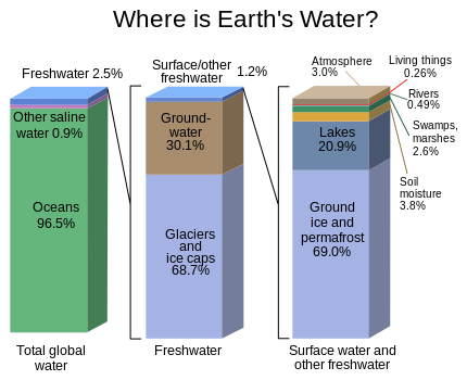
English: Graph of the locations of water on Earth |
| წყარო | https://water.usgs.gov/edu/gallery/watercyclekids/earth-water-distribution.html - traced and redrawn from File:Earth's water distribution.gif |
| ავტორი | USGS |
| სხვა ვერსიები | Earth's water distribution-gl.svg |
| SVG genesis | ამ SVG ფაილის კოდი კორექტულია. This vector image was created with Inkscape. |
ლიცენზია
This image is in the public domain in the United States because it only contains materials that originally came from the United States Geological Survey, an agency of the United States Department of the Interior. For more information, see the official USGS copyright policy.
|
ფაილის ისტორია
დააწკაპუნეთ თარიღზე/დროზე ფაილის დასათვალიერებლად, როგორც ის მაშინ გამოიყურებოდა.
| თარიღი/დრო | მინიატიურა | ზომები | მომხმარებელი | შენიშვნა | |
|---|---|---|---|---|---|
| მიმდინარე | 22:28, 31 იანვარი 2024 | | 430×350 (31 კბ) | Asierog | spanish and french translations added |
| 12:32, 22 ნოემბერი 2016 |  | 430×350 (25 კბ) | MaxxL | updated | |
| 14:00, 22 მაისი 2010 |  | 530×368 (202 კბ) | Begoon | {{Information |Description={{en|1=Graph of the locations of water on Earth}} |Source=http://ga.water.usgs.gov/edu/waterdistribution.html |Author=USGS |Date= |Permission= |other_versions= }} |
ბმულები
ამ ფაილზე ბმული მოცემულია შემდეგ გვერდებზე:
ფაილის გლობალური გამოყენება
ეს ფაილი გამოიყენება შემდეგ ვიკებში:
- გამოყენება el.wikipedia.org-ში
- გამოყენება en.wikipedia.org-ში
- გამოყენება en.wikibooks.org-ში
- გამოყენება en.wikiversity.org-ში
- გამოყენება es.wikipedia.org-ში
- გამოყენება et.wikipedia.org-ში
- გამოყენება eu.wikipedia.org-ში
- გამოყენება fr.wikipedia.org-ში
- გამოყენება gu.wikipedia.org-ში
- გამოყენება hi.wikipedia.org-ში
- გამოყენება hy.wikipedia.org-ში
- გამოყენება ms.wikipedia.org-ში
- გამოყენება si.wikipedia.org-ში
- გამოყენება te.wikipedia.org-ში
- გამოყენება tr.wikipedia.org-ში
- გამოყენება vi.wikipedia.org-ში
- გამოყენება zh.wikipedia.org-ში