თავდაპირველი ფაილი((1 545 × 1 242 პიქსელი, ფაილის ზომა: 187 კბ, MIME ტიპი: image/gif), დარგოლილი, 14 კადრი, 44 წმ)

ეს ფაილი მდებარეობს Wikimedia Commons სერვერზე.
იხილეთ მისი აღწერის გვერდი სრული ინფორმაციისთვის.
გადასვლა ფაილის გვერდზე
This image could be re-created using vector graphics as an SVG file. This has several advantages; see Commons:Media for cleanup for more information. If an SVG form of this image is available, please upload it and afterwards replace this template with {{vector version available|new image name}}. It is recommended to name the SVG file "Breakup of Yugoslavia.svg" - then the template Vector version available (or Vva) does not need the new image name parameter.

რეზიუმე

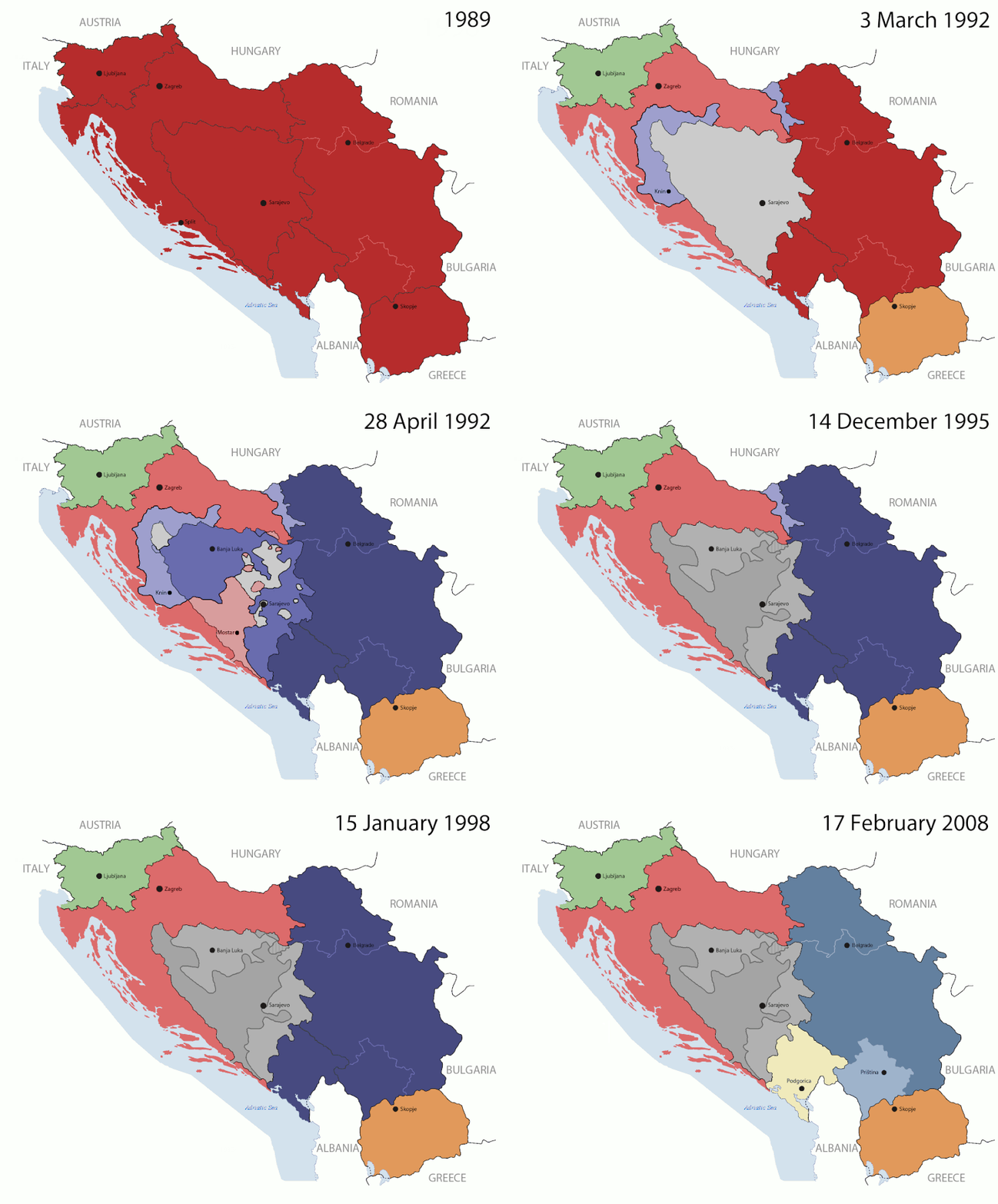
Key:

Yugoslavia (1943–1992) SFR Yugoslavia
Croatia (1991–present) Croatia
Herzeg-Bosnia (1992–1994)
UNTAES (1996–1998)
Federal Republic of Yugoslavia / Serbia and Montenegro (1992–2006) Serbia and Montenegro
Republika Srpska (1992–present) Republika Srpska
Serbian Krajina (1991–1995/96)
Republic of Bosnia and Herzegovina (1992–1995)
Bosnia and Herzegovina (1998–present) Bosnia and Herzegovina
Western Bosnia (1993–1995)
Serbia (2006–present) Serbia
Kosovo (under UNMIK control 1999–present; declaration of independence 2008) Kosovo
Montenegro (2006–present) Montenegro
Macedonia (1991–present) Macedonia
Slovenia (1991–present) Slovenia


აღწერა

This is an animated GIF that shows the stages of the breakup of the SFR Yugoslavia in the 90's and 2000's. The map based off Morwen's map of the divisions of the SFRY, Which is licensed by the GFDL. The source for the dates of independence is the CIA World Factbook. These maps do not now show the Inter-Entity Boundary Line (IEBL) and/or the entities that are separated by it. The IEBL has been drawn based on this CIA map; the Brčko District has been drawn based on Image:BH municipality location.gif, by user:Ante Perkovic. I might add them in the future.

Since the original map was GFDL, this image is as well.

A map depicting Kosovo's final status is ready once it takes effect.


Changelog for versions 2/3:

Here are some changes in this new build of the map:

  • The Kosovo boundary has been given a shade of red instead of the previous UN blue since they are a province of Serbia under UNIMIK control.
  • Montenegro's color has been changed to a golden shade close to what's on the flag.
  • The IEBL and the Brčko District has been redrawn because I deleted the original map; the color for the Republika Srpska is lighter.
  • The dates are at the top left hand corner of the map instead of the bottom.
  • I have taken a new approach as to the boundaries. Each part of Yugoslavia now shows the boundary on the maps starting the year they broke away. I feel this change helps readers understand the breakup better.
  • The SFRY and the FRY are in different shades since the FRY was never accepted as the successor to the former by the UN.
  • The colors for the entities of BiH have been removed as to not confuse people into thinking that they are independent states. What remains is the IEBL with both entities in green.
  • The Kosovo boundary is finally in hash marks!
  • The Brčko District has been removed. The sale is too small to show accurately.

Changelog for version 4:

  • The map is larger!
  • The image has been rebuilt to include the eastern part of FYR Macedonia.
  • The image has been updated to take in Kosovo's new status.
  • The IEBL is now a darker line.
  • Montenegro, Kosovo, and FRY/SCG/Serbia have new colors!

Changelog for version 5:

  • Rebuilt
  • Larger map: size of base image
  • Accurate Inter-Entity Boundary Line
თარიღი 24 July 2006 (orginal upload date)
წყარო Made by Hoshie; see above for more details on sources.
ავტორი Hoshie
სხვა ვერსიები

ლიცენზია

GNU head თქვენ შეგიძიათ გაავრცელოთ ან შეცვალოთ დოკუმენტი GNU Free Documentation ლიცენზიის 1.2 ან უფრო გვიანდელი ვერსიის პირობების თანახმად, რომელიც გამოქვეყნებულია თავისუფალი პროგრამული უზრუნველყოფის ფონდის მიერ, შეუცვლელი განყოფილებების გარეშე, პირველ და ბოლო გვერდებზე განთავსებულ ტექსტებზე. ლიცენზიის ასლი არის განთავსებული განყოფილებაში სახელად GNU Free Documentation License.
w:ka:Creative Commons
მოხსენიება გავრცელება იგივე პირობებეით
ეს ნამუშევარი ვრცელდება Creative Commons Attribution-Share Alike 3.0 Unported ლიცენზიით.
თქვენ თავისუფლად შეგიძლიათ:
  • ნამუშევრის გაზიარება – ნამუშევრის კოპირება, გავრცელება და გადაცემა.
  • შექმნათ დაფუძნებულები – ნამუშევრის შესწორება
შემდეგი პირობებით:
  • მოხსენიება – თქვენ უნდა მიუთითოთ წყაროს შემქმნელი იმ გზით, რომელიც დანიშნა ავტორმა ან საავტორო უფლებების მფლობელმა. მაგრამ არა ისე, თითქოს წყაროს ავტორი მხარს გიჭერთ თქვენ ან დაუჭირა თქვენს მიერ შექმნილ ნაწარმოებს.
  • გავრცელება იგივე პირობებეით – თუ თქვენ ცვლით, ან ქმნით ახალ ნაშრომს ამ ნამუშევრის გამოყენებთ, თქვენ გაქვთ უფლება გაავრცელოთ იგი იგივე ან შესაბამისი ლიცენზიით, რომლითაც ვრცელდება წყარო.
ეს ლიცენზირების ნიშანი დაემატა ამ ფაილს, როგორც GFDL ლიცენზიის განახლების ნაწილი.

Captions

Add a one-line explanation of what this file represents

media type ინგლისური

image/gif

checksum ინგლისური

05ca2aefea8406b809968643552d5095c847a42f

data size ინგლისური

191625 ბაიტი

ფაილის ისტორია

დააწკაპუნეთ თარიღზე/დროზე ფაილის დასათვალიერებლად, როგორც ის მაშინ გამოიყურებოდა.

(უკანასკნელი | პირველი) იხილე (უახლესი 10) () (10 | 20 | 50 | 100 | 250 | 500).
თარიღი/დრომინიატიურაზომებიმომხმარებელიშენიშვნა
მიმდინარე07:40, 17 ივლისი 2016მინიატურა 07:40, 17 ივლისი 2016 ვერსიისთვის1 545×1 242 (187 კბ)מפתח-רשימהReverted to version as of 17:22, 21 August 2015 (UTC)
17:22, 21 აგვისტო 2015მინიატურა 17:22, 21 აგვისტო 2015 ვერსიისთვის1 463×1 158 (1,81 მბ)BraganzaReverted to version as of 03:57, 19 January 2010
17:22, 21 აგვისტო 2015მინიატურა 17:22, 21 აგვისტო 2015 ვერსიისთვის1 545×1 242 (187 კბ)BraganzaReverted to version as of 01:02, 19 December 2011
17:15, 21 აგვისტო 2015მინიატურა 17:15, 21 აგვისტო 2015 ვერსიისთვის120×95 (3 კბ)Braganza03:57, 19. Jan. 2010
01:02, 19 დეკემბერი 2011მინიატურა 01:02, 19 დეკემბერი 2011 ვერსიისთვის1 545×1 242 (187 კბ)DIREKTORAdded details
18:09, 27 ივლისი 2011მინიატურა 18:09, 27 ივლისი 2011 ვერსიისთვის1 545×1 242 (170 კბ)DIREKTORSmall fixes
17:28, 27 ივლისი 2011მინიატურა 17:28, 27 ივლისი 2011 ვერსიისთვის1 545×1 242 (171 კბ)DIREKTORAdded UNMIK
16:38, 27 ივლისი 2011მინიატურა 16:38, 27 ივლისი 2011 ვერსიისთვის1 545×1 242 (165 კბ)DIREKTORDates for the last two frames.
12:10, 27 ივლისი 2011მინიატურა 12:10, 27 ივლისი 2011 ვერსიისთვის1 545×1 242 (149 კბ)DIREKTORLighter shade for country names
16:59, 26 ივლისი 2011მინიატურა 16:59, 26 ივლისი 2011 ვერსიისთვის1 545×1 242 (170 კბ)DIREKTORHigher res plus details
(უკანასკნელი | პირველი) იხილე (უახლესი 10) () (10 | 20 | 50 | 100 | 250 | 500).

ამ ფაილზე ბმული მოცემულია შემდეგ გვერდებზე:

ფაილის გლობალური გამოყენება

ეს ფაილი გამოიყენება შემდეგ ვიკებში:

იხილეთ, ამ ფაილის გლობალური გამოყენება.

მეტამონაცემები